You are here: Home > Network List > US - United States National Seismic Network Stations List
> Station SDCO Great Sand Dunes National Park, Colorado, USA > Earthquake Result Viewer
SDCO Great Sand Dunes National Park, Colorado, USA - Earthquake Result Viewer
| Earthquake location: |
East Of Kuril Islands |
| Earthquake latitude/longitude: |
49.0/157.7 |
| Earthquake time(UTC): |
2020/03/25 (085) 02:49:21 GMT |
| Earthquake Depth: |
57 km |
| Earthquake Magnitude: |
7.5 Mww |
| Earthquake Catalog/Contributor: |
NEIC PDE/us |
|
| Network: |
US United States National Seismic Network |
| Station: |
SDCO Great Sand Dunes National Park, Colorado, USA |
| Lat/Lon: |
37.75 N/105.50 W |
| Elevation: |
2569 m |
|
| Distance: |
66.6 deg |
| Az: |
59.039 deg |
| Baz: |
314.554 deg |
| Ray Param: |
0.0573696 |
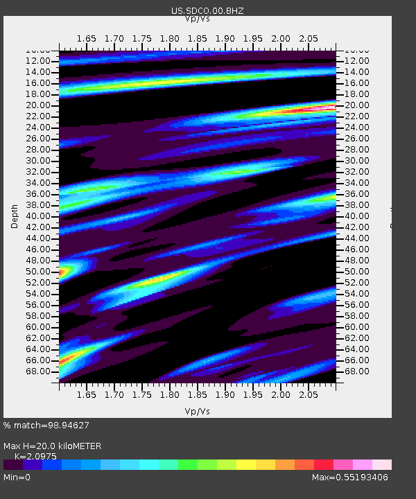
| Estimated Moho Depth: |
20.0 km |
| Estimated Crust Vp/Vs: |
2.10 |
| Assumed Crust Vp: |
6.316 km/s |
| Estimated Crust Vs: |
3.011 km/s |
| Estimated Crust Poisson's Ratio: |
0.35 |
|
| Radial Match: |
98.94627 % |
| Radial Bump: |
263 |
| Transverse Match: |
97.26259 % |
| Transverse Bump: |
397 |
| SOD ConfigId: |
20906531 |
| Insert Time: |
2020-04-08 15:22:26.787 +0000 |
| GWidth: |
2.5 |
| Max Bumps: |
400 |
| Tol: |
0.001 |
|
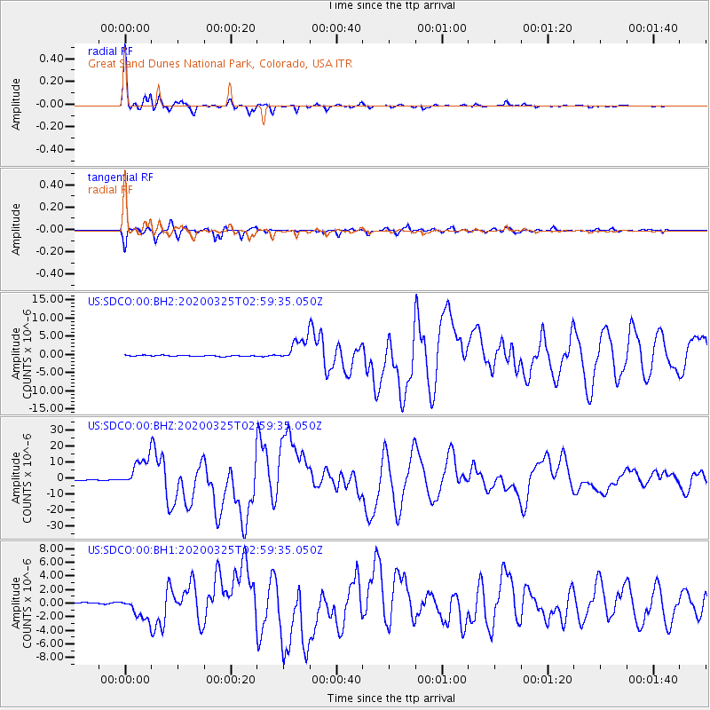
Signal To Noise
| Channel | StoN | STA | LTA |
| US:SDCO:00:BHZ:20200325T02:59:35.050Z | 34.822872 | 9.4768975E-6 | 2.7214577E-7 |
| US:SDCO:00:BH1:20200325T02:59:35.050Z | 12.570555 | 1.6428618E-6 | 1.3069128E-7 |
| US:SDCO:00:BH2:20200325T02:59:35.050Z | 23.273375 | 3.3190536E-6 | 1.4261161E-7 |
| Arrivals |
| Ps | 3.6 SECOND |
| PpPs | 9.5 SECOND |
| PsPs/PpSs | 13 SECOND |


