You are here: Home > Network List > US - United States National Seismic Network Stations List
> Station MNTX Cornudas Mountains, Texas, USA > Earthquake Result Viewer
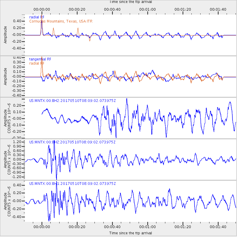
MNTX Cornudas Mountains, Texas, USA - Earthquake Result Viewer
*The percent match for this event was below the threshold and hence no stack was calculated.
| Earthquake location: |
Andreanof Islands, Aleutian Is. |
| Earthquake latitude/longitude: |
51.4/-178.5 |
| Earthquake time(UTC): |
2017/05/10 (130) 07:59:55 GMT |
| Earthquake Depth: |
1.0 km |
| Earthquake Magnitude: |
6.0 Mi |
| Earthquake Catalog/Contributor: |
NEIC PDE/at |
|
| Network: |
US United States National Seismic Network |
| Station: |
MNTX Cornudas Mountains, Texas, USA |
| Lat/Lon: |
31.70 N/105.38 W |
| Elevation: |
404 m |
|
| Distance: |
55.7 deg |
| Az: |
80.68 deg |
| Baz: |
313.565 deg |
| Ray Param: |
$rayparam |
*The percent match for this event was below the threshold and hence was not used in the summary stack. |
|
| Radial Match: |
66.70001 % |
| Radial Bump: |
383 |
| Transverse Match: |
71.507034 % |
| Transverse Bump: |
400 |
| SOD ConfigId: |
2028011 |
| Insert Time: |
2017-05-24 08:05:31.144 +0000 |
| GWidth: |
2.5 |
| Max Bumps: |
400 |
| Tol: |
0.001 |
|
Signal To Noise
| Channel | StoN | STA | LTA |
| US:MNTX:00:BHZ:20170510T08:09:02.073975Z | 5.901253 | 4.209419E-7 | 7.133093E-8 |
| US:MNTX:00:BH1:20170510T08:09:02.073975Z | 3.4443293 | 2.1504191E-7 | 6.243361E-8 |
| US:MNTX:00:BH2:20170510T08:09:02.073975Z | 1.8128897 | 1.084026E-7 | 5.9795475E-8 |
| Arrivals |
| Ps | |
| PpPs | |
| PsPs/PpSs | |


