You are here: Home > Network List > UU - University of Utah Regional Network Stations List
> Station LCMT Little Creek Mountain, UT, USA > Earthquake Result Viewer
LCMT Little Creek Mountain, UT, USA - Earthquake Result Viewer
| Earthquake location: |
East Of Kuril Islands |
| Earthquake latitude/longitude: |
49.0/157.7 |
| Earthquake time(UTC): |
2020/03/25 (085) 02:49:21 GMT |
| Earthquake Depth: |
57 km |
| Earthquake Magnitude: |
7.5 Mww |
| Earthquake Catalog/Contributor: |
NEIC PDE/us |
|
| Network: |
UU University of Utah Regional Network |
| Station: |
LCMT Little Creek Mountain, UT, USA |
| Lat/Lon: |
37.01 N/113.24 W |
| Elevation: |
1411 m |
|
| Distance: |
62.6 deg |
| Az: |
64.31 deg |
| Baz: |
312.13 deg |
| Ray Param: |
0.0599603 |
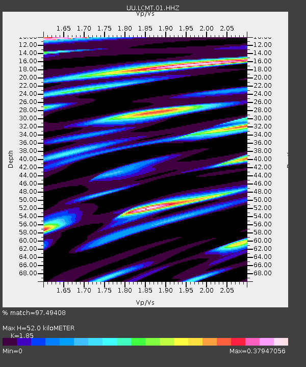
| Estimated Moho Depth: |
52.0 km |
| Estimated Crust Vp/Vs: |
1.85 |
| Assumed Crust Vp: |
6.194 km/s |
| Estimated Crust Vs: |
3.348 km/s |
| Estimated Crust Poisson's Ratio: |
0.29 |
|
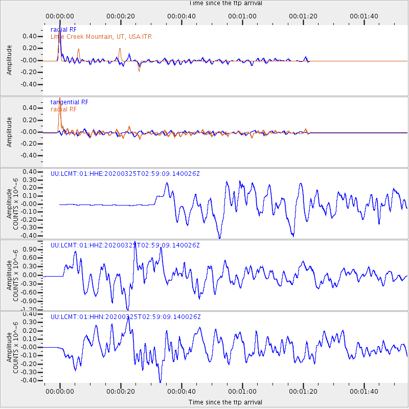
| Radial Match: |
97.49408 % |
| Radial Bump: |
362 |
| Transverse Match: |
87.423164 % |
| Transverse Bump: |
400 |
| SOD ConfigId: |
20906531 |
| Insert Time: |
2020-04-08 15:23:02.348 +0000 |
| GWidth: |
2.5 |
| Max Bumps: |
400 |
| Tol: |
0.001 |
|
Signal To Noise
| Channel | StoN | STA | LTA |
| UU:LCMT:01:HHZ:20200325T02:59:09.140026Z | 49.804703 | 2.933457E-7 | 5.889919E-9 |
| UU:LCMT:01:HHN:20200325T02:59:09.140026Z | 22.346966 | 9.399927E-8 | 4.206355E-9 |
| UU:LCMT:01:HHE:20200325T02:59:09.140026Z | 22.79635 | 9.330968E-8 | 4.093185E-9 |
| Arrivals |
| Ps | 7.4 SECOND |
| PpPs | 23 SECOND |
| PsPs/PpSs | 30 SECOND |


