You are here: Home > Network List > UW - Pacific Northwest Regional Seismic Network Stations List
> Station EPH2 Ephrata, WA, USA > Earthquake Result Viewer
EPH2 Ephrata, WA, USA - Earthquake Result Viewer
| Earthquake location: |
East Of Kuril Islands |
| Earthquake latitude/longitude: |
49.0/157.7 |
| Earthquake time(UTC): |
2020/03/25 (085) 02:49:21 GMT |
| Earthquake Depth: |
57 km |
| Earthquake Magnitude: |
7.5 Mww |
| Earthquake Catalog/Contributor: |
NEIC PDE/us |
|
| Network: |
UW Pacific Northwest Regional Seismic Network |
| Station: |
EPH2 Ephrata, WA, USA |
| Lat/Lon: |
47.37 N/119.61 W |
| Elevation: |
690 m |
|
| Distance: |
52.5 deg |
| Az: |
58.192 deg |
| Baz: |
304.553 deg |
| Ray Param: |
0.066574536 |
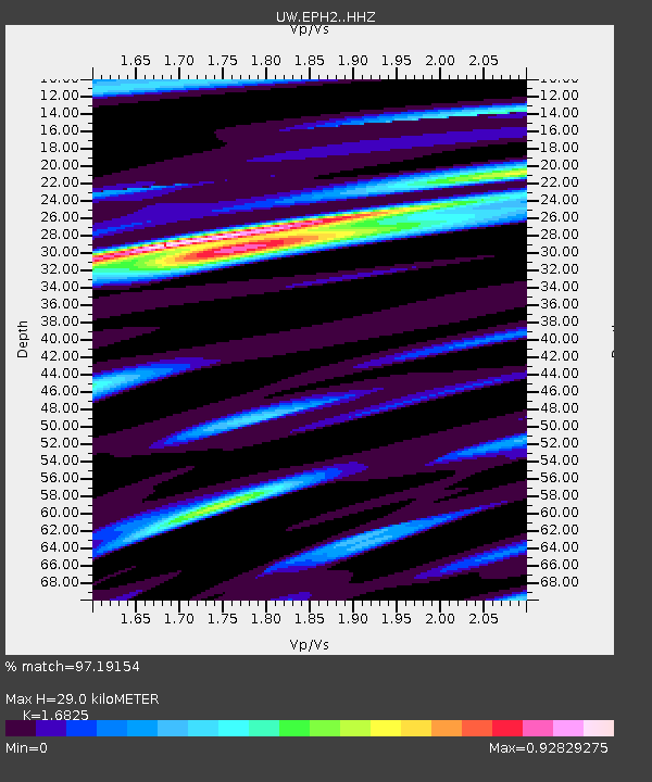
| Estimated Moho Depth: |
29.0 km |
| Estimated Crust Vp/Vs: |
1.68 |
| Assumed Crust Vp: |
6.419 km/s |
| Estimated Crust Vs: |
3.815 km/s |
| Estimated Crust Poisson's Ratio: |
0.23 |
|
| Radial Match: |
97.19154 % |
| Radial Bump: |
386 |
| Transverse Match: |
87.19475 % |
| Transverse Bump: |
400 |
| SOD ConfigId: |
20906531 |
| Insert Time: |
2020-04-08 15:23:48.450 +0000 |
| GWidth: |
2.5 |
| Max Bumps: |
400 |
| Tol: |
0.001 |
|

Signal To Noise
| Channel | StoN | STA | LTA |
| UW:EPH2: :HHZ:20200325T02:57:58.03999Z | 64.32799 | 1.3354792E-5 | 2.0760469E-7 |
| UW:EPH2: :HHN:20200325T02:57:58.03999Z | 22.326012 | 4.272211E-6 | 1.9135575E-7 |
| UW:EPH2: :HHE:20200325T02:57:58.03999Z | 34.591377 | 6.676432E-6 | 1.9300855E-7 |
| Arrivals |
| Ps | 3.3 SECOND |
| PpPs | 11 SECOND |
| PsPs/PpSs | 15 SECOND |


