You are here: Home > Network List > UW - Pacific Northwest Regional Seismic Network Stations List
> Station LRIV Port Angeles, WA, USA > Earthquake Result Viewer
LRIV Port Angeles, WA, USA - Earthquake Result Viewer
| Earthquake location: |
East Of Kuril Islands |
| Earthquake latitude/longitude: |
49.0/157.7 |
| Earthquake time(UTC): |
2020/03/25 (085) 02:49:21 GMT |
| Earthquake Depth: |
57 km |
| Earthquake Magnitude: |
7.5 Mww |
| Earthquake Catalog/Contributor: |
NEIC PDE/us |
|
| Network: |
UW Pacific Northwest Regional Seismic Network |
| Station: |
LRIV Port Angeles, WA, USA |
| Lat/Lon: |
48.06 N/123.50 W |
| Elevation: |
294 m |
|
| Distance: |
49.9 deg |
| Az: |
59.316 deg |
| Baz: |
302.386 deg |
| Ray Param: |
0.068239376 |
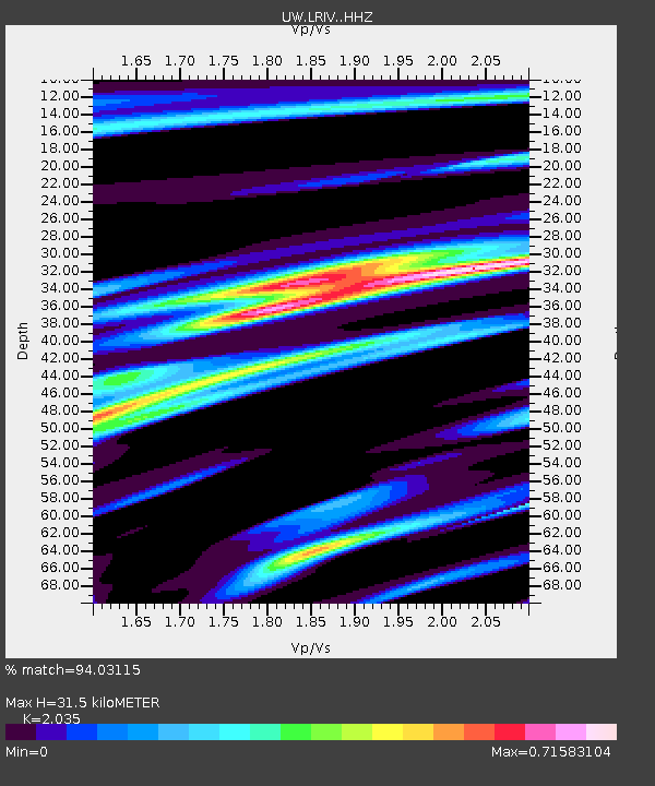
| Estimated Moho Depth: |
31.5 km |
| Estimated Crust Vp/Vs: |
2.04 |
| Assumed Crust Vp: |
6.566 km/s |
| Estimated Crust Vs: |
3.227 km/s |
| Estimated Crust Poisson's Ratio: |
0.34 |
|
| Radial Match: |
94.03115 % |
| Radial Bump: |
344 |
| Transverse Match: |
92.326775 % |
| Transverse Bump: |
400 |
| SOD ConfigId: |
20906531 |
| Insert Time: |
2020-04-08 15:24:15.189 +0000 |
| GWidth: |
2.5 |
| Max Bumps: |
400 |
| Tol: |
0.001 |
|

Signal To Noise
| Channel | StoN | STA | LTA |
| UW:LRIV: :HHZ:20200325T02:57:38.819989Z | 38.021507 | 1.1598059E-5 | 3.0503944E-7 |
| UW:LRIV: :HHN:20200325T02:57:38.819989Z | 11.716028 | 3.739626E-6 | 3.1918887E-7 |
| UW:LRIV: :HHE:20200325T02:57:38.819989Z | 21.224134 | 4.9964747E-6 | 2.3541477E-7 |
| Arrivals |
| Ps | 5.2 SECOND |
| PpPs | 14 SECOND |
| PsPs/PpSs | 19 SECOND |


