You are here: Home > Network List > UW - Pacific Northwest Regional Seismic Network Stations List
> Station WOLL Wollman Farm, Schrag, WA, USA > Earthquake Result Viewer
WOLL Wollman Farm, Schrag, WA, USA - Earthquake Result Viewer
| Earthquake location: |
East Of Kuril Islands |
| Earthquake latitude/longitude: |
49.0/157.7 |
| Earthquake time(UTC): |
2020/03/25 (085) 02:49:21 GMT |
| Earthquake Depth: |
57 km |
| Earthquake Magnitude: |
7.5 Mww |
| Earthquake Catalog/Contributor: |
NEIC PDE/us |
|
| Network: |
UW Pacific Northwest Regional Seismic Network |
| Station: |
WOLL Wollman Farm, Schrag, WA, USA |
| Lat/Lon: |
47.06 N/118.92 W |
| Elevation: |
385 m |
|
| Distance: |
53.1 deg |
| Az: |
58.178 deg |
| Baz: |
305.05 deg |
| Ray Param: |
0.06621204 |
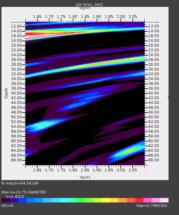
| Estimated Moho Depth: |
15.75 km |
| Estimated Crust Vp/Vs: |
1.65 |
| Assumed Crust Vp: |
6.419 km/s |
| Estimated Crust Vs: |
3.885 km/s |
| Estimated Crust Poisson's Ratio: |
0.21 |
|
| Radial Match: |
94.54169 % |
| Radial Bump: |
340 |
| Transverse Match: |
81.559204 % |
| Transverse Bump: |
400 |
| SOD ConfigId: |
20906531 |
| Insert Time: |
2020-04-08 15:25:00.430 +0000 |
| GWidth: |
2.5 |
| Max Bumps: |
400 |
| Tol: |
0.001 |
|
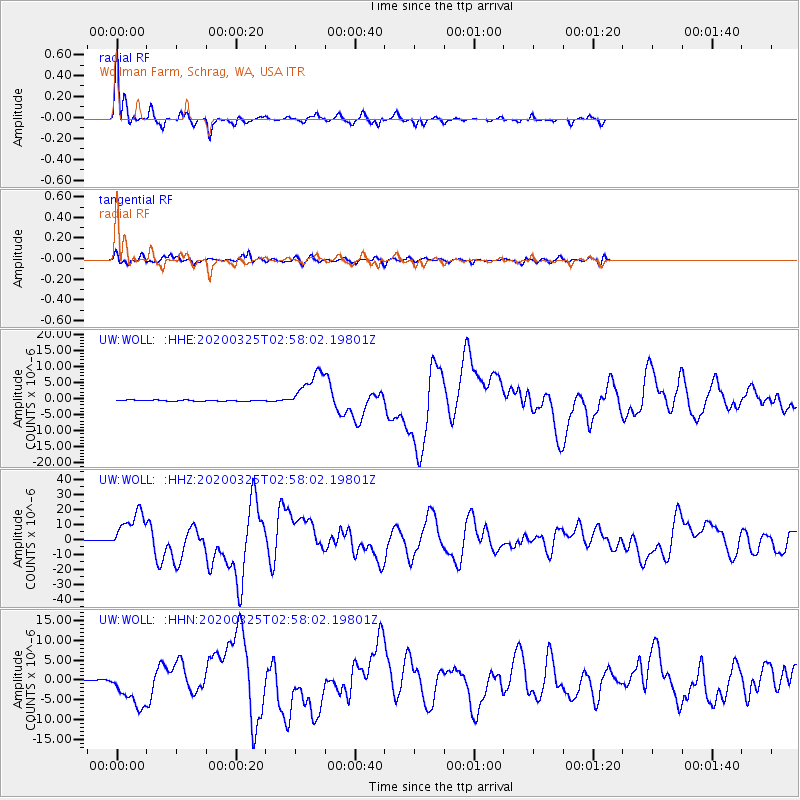
Signal To Noise
| Channel | StoN | STA | LTA |
| UW:WOLL: :HHZ:20200325T02:58:02.19801Z | 45.73188 | 1.3124358E-5 | 2.8698486E-7 |
| UW:WOLL: :HHN:20200325T02:58:02.19801Z | 20.563375 | 4.837677E-6 | 2.3525695E-7 |
| UW:WOLL: :HHE:20200325T02:58:02.19801Z | 38.066845 | 5.940019E-6 | 1.5604179E-7 |
| Arrivals |
| Ps | 1.7 SECOND |
| PpPs | 6.1 SECOND |
| PsPs/PpSs | 7.8 SECOND |


