You are here: Home > Network List > WI - West Indies IPGP Network Stations List
> Station BIM Morne Bigot, Anses d'Arlets, Martinique > Earthquake Result Viewer
BIM Morne Bigot, Anses d'Arlets, Martinique - Earthquake Result Viewer
| Earthquake location: |
Northern California |
| Earthquake latitude/longitude: |
40.3/-122.4 |
| Earthquake time(UTC): |
2020/03/25 (085) 02:58:37 GMT |
| Earthquake Depth: |
65 km |
| Earthquake Magnitude: |
5.4 Mw |
| Earthquake Catalog/Contributor: |
NEIC PDE/nc |
|
| Network: |
WI West Indies IPGP Network |
| Station: |
BIM Morne Bigot, Anses d'Arlets, Martinique |
| Lat/Lon: |
14.52 N/61.07 W |
| Elevation: |
391 m |
|
| Distance: |
59.0 deg |
| Az: |
97.29 deg |
| Baz: |
308.458 deg |
| Ray Param: |
0.062331367 |
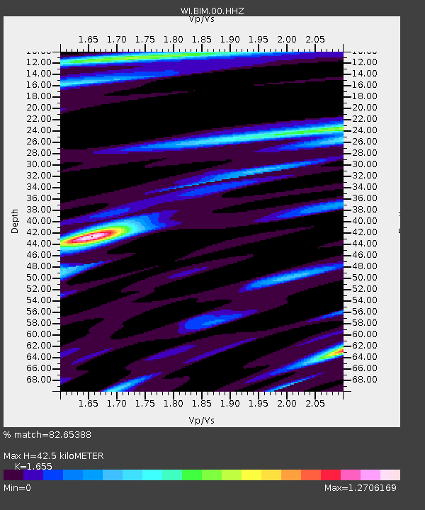
| Estimated Moho Depth: |
42.5 km |
| Estimated Crust Vp/Vs: |
1.65 |
| Assumed Crust Vp: |
5.88 km/s |
| Estimated Crust Vs: |
3.553 km/s |
| Estimated Crust Poisson's Ratio: |
0.21 |
|
| Radial Match: |
82.65388 % |
| Radial Bump: |
400 |
| Transverse Match: |
71.535446 % |
| Transverse Bump: |
400 |
| SOD ConfigId: |
20906531 |
| Insert Time: |
2020-04-08 15:36:16.962 +0000 |
| GWidth: |
2.5 |
| Max Bumps: |
400 |
| Tol: |
0.001 |
|
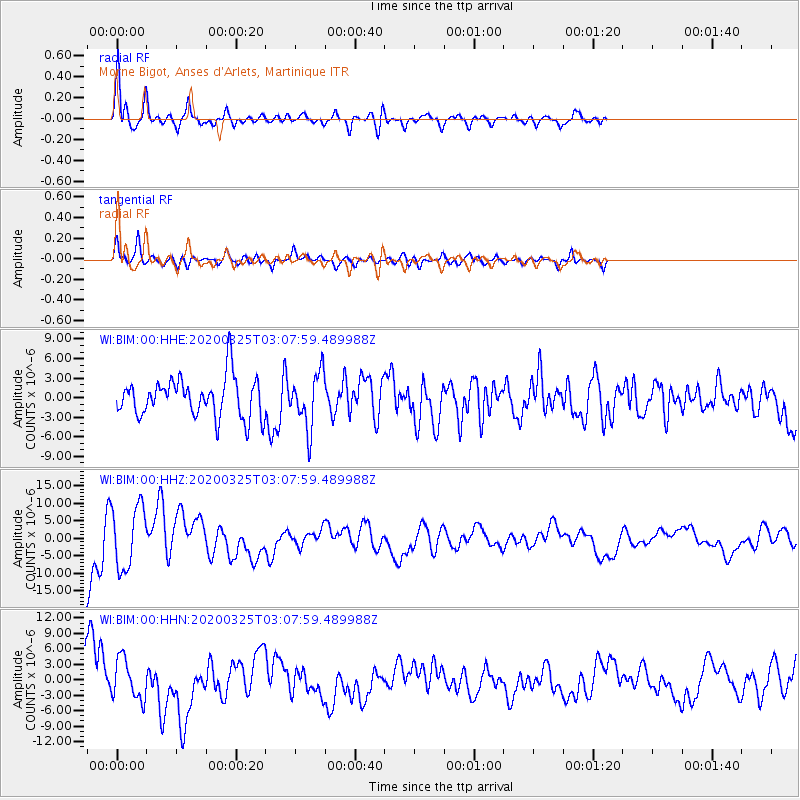
Signal To Noise
| Channel | StoN | STA | LTA |
| WI:BIM:00:HHZ:20200325T03:07:59.489988Z | 1.164868 | 8.917366E-6 | 7.655259E-6 |
| WI:BIM:00:HHN:20200325T03:07:59.489988Z | 1.1855364 | 3.941355E-6 | 3.324533E-6 |
| WI:BIM:00:HHE:20200325T03:07:59.489988Z | 1.3885659 | 4.145541E-6 | 2.9854841E-6 |
| Arrivals |
| Ps | 4.9 SECOND |
| PpPs | 18 SECOND |
| PsPs/PpSs | 23 SECOND |


