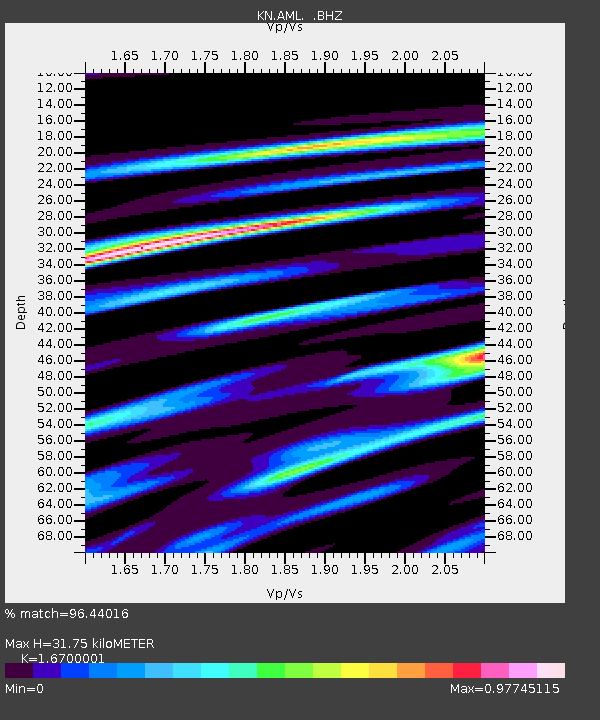
AML KN.AML - Earthquake Result Viewer

Earthquake location: Kuril Islands
Earthquake latitude/longitude: 43.9/147.9
Earthquake time(UTC): 1994/10/09 (282) 07:55:38 GMT
Earthquake Depth: 23 km
Earthquake Magnitude: 6.5 MB, 7.0 MS, 6.7 UNKNOWN, 7.3 MW
Earthquake Catalog/Contributor: WHDF/NEIC
Network: KN Kyrgyz Seismic Telemetry Network
Station: AML KN.AML
Lat/Lon: 42.13 N/73.69 E
Elevation: 3400 m
Distance: 52.5 deg
Az: 295.622 deg
Baz: 61.194 deg
Ray Param: 0.06665749
Estimated Moho Depth: 31.75 km
Estimated Crust Vp/Vs: 1.67
Assumed Crust Vp: 6.316 km/s
Estimated Crust Vs: 3.782 km/s
Estimated Crust Poisson's Ratio: 0.22
Radial Match: 96.44016 %
Radial Bump: 400
Transverse Match: 84.85918 %
Transverse Bump: 400
SOD ConfigId: 4480
Insert Time: 2010-03-08 18:47:51.193 +0000
GWidth: 2.5
Max Bumps: 400
Tol: 0.001

Signal To Noise

ChannelStoNSTALTA
KN:AML: :BHZ:19941009T08:04:18.598999Z32.6931722.3103605E-67.066798E-8
KN:AML: :BHN:19941009T08:04:18.598999Z8.7356534.6729775E-75.3493167E-8
KN:AML: :BHE:19941009T08:04:18.598999Z11.2996089.01002E-77.9737454E-8
Arrivals
Ps3.6 SECOND
PpPs13 SECOND
PsPs/PpSs16 SECOND