You are here: Home > Network List > TA - USArray Transportable Network (new EarthScope stations) Stations List
> Station G16K Koyuk River, AK, USA > Earthquake Result Viewer
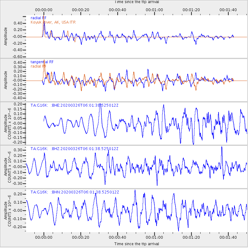
G16K Koyuk River, AK, USA - Earthquake Result Viewer
*The percent match for this event was below the threshold and hence no stack was calculated.
| Earthquake location: |
Volcano Islands, Japan Region |
| Earthquake latitude/longitude: |
22.7/143.2 |
| Earthquake time(UTC): |
2020/03/26 (086) 05:52:48 GMT |
| Earthquake Depth: |
105 km |
| Earthquake Magnitude: |
5.4 Mww |
| Earthquake Catalog/Contributor: |
NEIC PDE/us |
|
| Network: |
TA USArray Transportable Network (new EarthScope stations) |
| Station: |
G16K Koyuk River, AK, USA |
| Lat/Lon: |
65.39 N/162.35 W |
| Elevation: |
169 m |
|
| Distance: |
55.0 deg |
| Az: |
24.568 deg |
| Baz: |
246.481 deg |
| Ray Param: |
$rayparam |
*The percent match for this event was below the threshold and hence was not used in the summary stack. |
|
| Radial Match: |
68.52441 % |
| Radial Bump: |
400 |
| Transverse Match: |
62.92522 % |
| Transverse Bump: |
364 |
| SOD ConfigId: |
20906531 |
| Insert Time: |
2020-04-09 06:05:39.455 +0000 |
| GWidth: |
2.5 |
| Max Bumps: |
400 |
| Tol: |
0.001 |
|
Signal To Noise
| Channel | StoN | STA | LTA |
| TA:G16K: :BHZ:20200326T06:01:38.525012Z | 1.9869854 | 1.26247E-7 | 6.353696E-8 |
| TA:G16K: :BHN:20200326T06:01:38.525012Z | 0.47455734 | 4.7824212E-8 | 1.0077647E-7 |
| TA:G16K: :BHE:20200326T06:01:38.525012Z | 2.4981065 | 1.12026356E-7 | 4.484451E-8 |
| Arrivals |
| Ps | |
| PpPs | |
| PsPs/PpSs | |


