You are here: Home > Network List > TA - USArray Transportable Network (new EarthScope stations) Stations List
> Station G21K Allakaket, AK, USA > Earthquake Result Viewer
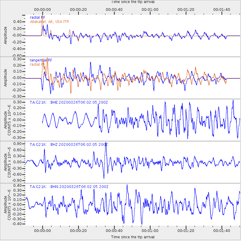
G21K Allakaket, AK, USA - Earthquake Result Viewer
*The percent match for this event was below the threshold and hence no stack was calculated.
| Earthquake location: |
Volcano Islands, Japan Region |
| Earthquake latitude/longitude: |
22.7/143.2 |
| Earthquake time(UTC): |
2020/03/26 (086) 05:52:48 GMT |
| Earthquake Depth: |
105 km |
| Earthquake Magnitude: |
5.4 Mww |
| Earthquake Catalog/Contributor: |
NEIC PDE/us |
|
| Network: |
TA USArray Transportable Network (new EarthScope stations) |
| Station: |
G21K Allakaket, AK, USA |
| Lat/Lon: |
66.52 N/153.51 W |
| Elevation: |
446 m |
|
| Distance: |
58.8 deg |
| Az: |
24.742 deg |
| Baz: |
254.651 deg |
| Ray Param: |
$rayparam |
*The percent match for this event was below the threshold and hence was not used in the summary stack. |
|
| Radial Match: |
69.79858 % |
| Radial Bump: |
400 |
| Transverse Match: |
71.77811 % |
| Transverse Bump: |
400 |
| SOD ConfigId: |
20906531 |
| Insert Time: |
2020-04-09 06:05:42.824 +0000 |
| GWidth: |
2.5 |
| Max Bumps: |
400 |
| Tol: |
0.001 |
|
Signal To Noise
| Channel | StoN | STA | LTA |
| TA:G21K: :BHZ:20200326T06:02:05.200Z | 1.8269613 | 2.4450344E-7 | 1.3383067E-7 |
| TA:G21K: :BHN:20200326T06:02:05.200Z | 0.7954902 | 9.3368435E-8 | 1.17372196E-7 |
| TA:G21K: :BHE:20200326T06:02:05.200Z | 1.6718334 | 1.2348687E-7 | 7.386314E-8 |
| Arrivals |
| Ps | |
| PpPs | |
| PsPs/PpSs | |


