You are here: Home > Network List > US - United States National Seismic Network Stations List
> Station EGMT Eagleton, Montana, USA > Earthquake Result Viewer
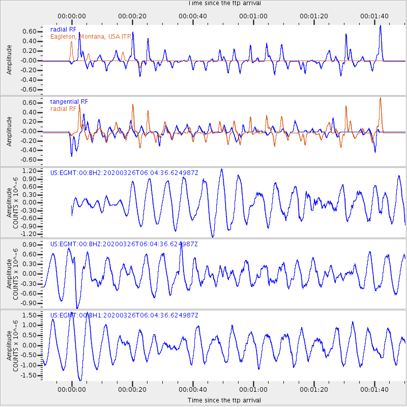
EGMT Eagleton, Montana, USA - Earthquake Result Viewer
*The percent match for this event was below the threshold and hence no stack was calculated.
| Earthquake location: |
Volcano Islands, Japan Region |
| Earthquake latitude/longitude: |
22.7/143.2 |
| Earthquake time(UTC): |
2020/03/26 (086) 05:52:48 GMT |
| Earthquake Depth: |
105 km |
| Earthquake Magnitude: |
5.4 Mww |
| Earthquake Catalog/Contributor: |
NEIC PDE/us |
|
| Network: |
US United States National Seismic Network |
| Station: |
EGMT Eagleton, Montana, USA |
| Lat/Lon: |
48.02 N/109.75 W |
| Elevation: |
1055 m |
|
| Distance: |
84.1 deg |
| Az: |
40.185 deg |
| Baz: |
297.433 deg |
| Ray Param: |
$rayparam |
*The percent match for this event was below the threshold and hence was not used in the summary stack. |
|
| Radial Match: |
73.76898 % |
| Radial Bump: |
353 |
| Transverse Match: |
64.65295 % |
| Transverse Bump: |
382 |
| SOD ConfigId: |
20906531 |
| Insert Time: |
2020-04-09 06:07:37.749 +0000 |
| GWidth: |
2.5 |
| Max Bumps: |
400 |
| Tol: |
0.001 |
|
Signal To Noise
| Channel | StoN | STA | LTA |
| US:EGMT:00:BHZ:20200326T06:04:36.624987Z | 2.0571132 | 6.0937515E-7 | 2.962283E-7 |
| US:EGMT:00:BH1:20200326T06:04:36.624987Z | 2.215056 | 1.2429699E-6 | 5.6114607E-7 |
| US:EGMT:00:BH2:20200326T06:04:36.624987Z | 2.0445805 | 6.469676E-7 | 3.164305E-7 |
| Arrivals |
| Ps | |
| PpPs | |
| PsPs/PpSs | |


