You are here: Home > Network List > KN - Kyrgyz Seismic Telemetry Network Stations List
> Station AML KN.AML > Earthquake Result Viewer
AML KN.AML - Earthquake Result Viewer
| Earthquake location: |
New Ireland Region, P.N.G. |
| Earthquake latitude/longitude: |
-5.2/153.7 |
| Earthquake time(UTC): |
2009/06/23 (174) 14:19:17 GMT |
| Earthquake Depth: |
65 km |
| Earthquake Magnitude: |
5.5 MB |
| Earthquake Catalog/Contributor: |
WHDF/NEIC |
|
| Network: |
KN Kyrgyz Seismic Telemetry Network |
| Station: |
AML KN.AML |
| Lat/Lon: |
42.13 N/73.69 E |
| Elevation: |
3400 m |
|
| Distance: |
86.1 deg |
| Az: |
312.754 deg |
| Baz: |
100.542 deg |
| Ray Param: |
0.04418946 |
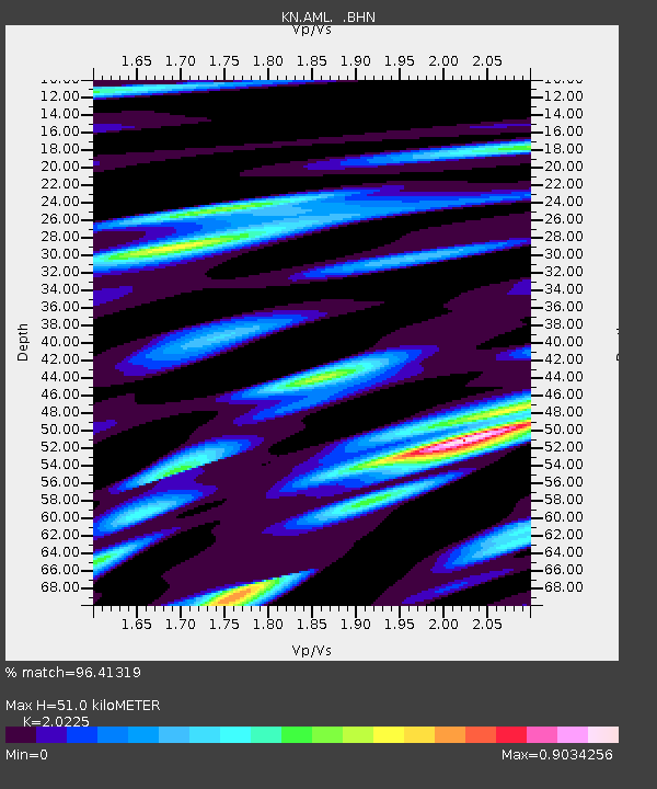
| Estimated Moho Depth: |
51.0 km |
| Estimated Crust Vp/Vs: |
2.02 |
| Assumed Crust Vp: |
6.316 km/s |
| Estimated Crust Vs: |
3.123 km/s |
| Estimated Crust Poisson's Ratio: |
0.34 |
|
| Radial Match: |
96.41319 % |
| Radial Bump: |
400 |
| Transverse Match: |
92.94682 % |
| Transverse Bump: |
400 |
| SOD ConfigId: |
2648 |
| Insert Time: |
2010-03-08 18:48:51.705 +0000 |
| GWidth: |
2.5 |
| Max Bumps: |
400 |
| Tol: |
0.001 |
|

Signal To Noise
| Channel | StoN | STA | LTA |
| KN:AML: :BHN:20090623T14:31:20.275015Z | 12.791425 | 4.7491642E-7 | 3.712772E-8 |
| KN:AML: :BHE:20090623T14:31:20.275015Z | 2.642003 | 8.139865E-8 | 3.0809446E-8 |
| KN:AML: :BHZ:20090623T14:31:20.275015Z | 7.185367 | 1.5903878E-7 | 2.2133703E-8 |
| Arrivals |
| Ps | 8.4 SECOND |
| PpPs | 24 SECOND |
| PsPs/PpSs | 32 SECOND |


