You are here: Home > Network List > CM - Red Sismologica Nacional de Columbia Stations List
> Station PRV Islas San Andres y Providencia, Colombia > Earthquake Result Viewer
PRV Islas San Andres y Providencia, Colombia - Earthquake Result Viewer
| Earthquake location: |
South Sandwich Islands Region |
| Earthquake latitude/longitude: |
-56.3/-25.5 |
| Earthquake time(UTC): |
2017/05/10 (130) 23:23:39 GMT |
| Earthquake Depth: |
41 km |
| Earthquake Magnitude: |
6.8 Mi |
| Earthquake Catalog/Contributor: |
NEIC PDE/pt |
|
| Network: |
CM Red Sismologica Nacional de Columbia |
| Station: |
PRV Islas San Andres y Providencia, Colombia |
| Lat/Lon: |
13.38 N/81.36 W |
| Elevation: |
205 m |
|
| Distance: |
83.5 deg |
| Az: |
305.842 deg |
| Baz: |
152.33 deg |
| Ray Param: |
0.04610384 |
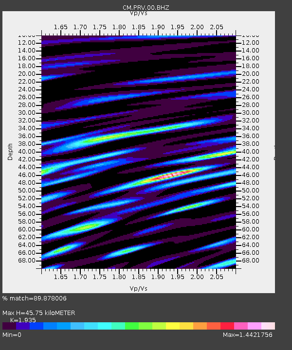
| Estimated Moho Depth: |
45.75 km |
| Estimated Crust Vp/Vs: |
1.93 |
| Assumed Crust Vp: |
6.048 km/s |
| Estimated Crust Vs: |
3.126 km/s |
| Estimated Crust Poisson's Ratio: |
0.32 |
|
| Radial Match: |
89.878006 % |
| Radial Bump: |
400 |
| Transverse Match: |
88.540375 % |
| Transverse Bump: |
400 |
| SOD ConfigId: |
2028011 |
| Insert Time: |
2017-05-24 23:25:41.649 +0000 |
| GWidth: |
2.5 |
| Max Bumps: |
400 |
| Tol: |
0.001 |
|

Signal To Noise
| Channel | StoN | STA | LTA |
| CM:PRV:00:BHZ:20170510T23:35:31.218994Z | 2.8238785 | 8.844682E-8 | 3.132104E-8 |
| CM:PRV:00:BHN:20170510T23:35:31.218994Z | 1.2256925 | 3.741721E-8 | 3.0527403E-8 |
| CM:PRV:00:BHE:20170510T23:35:31.218994Z | 1.1019034 | 2.7013579E-8 | 2.451538E-8 |
| Arrivals |
| Ps | 7.2 SECOND |
| PpPs | 22 SECOND |
| PsPs/PpSs | 29 SECOND |


