You are here: Home > Network List > TS - TERRAscope (Southern California Seismic Network) Stations List
> Station RPV Rancho Palos Verde California, USA > Earthquake Result Viewer
RPV Rancho Palos Verde California, USA - Earthquake Result Viewer
*The percent match for this event was below the threshold and hence no stack was calculated.
| Earthquake location: |
Mariana Islands Region |
| Earthquake latitude/longitude: |
21.8/142.6 |
| Earthquake time(UTC): |
1995/04/08 (098) 17:45:18 GMT |
| Earthquake Depth: |
319 km |
| Earthquake Magnitude: |
6.3 MB |
| Earthquake Catalog/Contributor: |
WHDF/NEIC |
|
| Network: |
TS TERRAscope (Southern California Seismic Network) |
| Station: |
RPV Rancho Palos Verde California, USA |
| Lat/Lon: |
33.74 N/118.40 W |
| Elevation: |
115 m |
|
| Distance: |
85.2 deg |
| Az: |
55.685 deg |
| Baz: |
292.9 deg |
| Ray Param: |
$rayparam |
*The percent match for this event was below the threshold and hence was not used in the summary stack. |
|
| Radial Match: |
61.273705 % |
| Radial Bump: |
400 |
| Transverse Match: |
54.930477 % |
| Transverse Bump: |
400 |
| SOD ConfigId: |
4480 |
| Insert Time: |
2010-02-26 14:45:41.943 +0000 |
| GWidth: |
2.5 |
| Max Bumps: |
400 |
| Tol: |
0.001 |
|
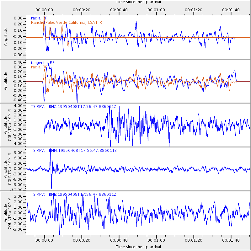
Signal To Noise
| Channel | StoN | STA | LTA |
| TS:RPV: :BHN:19950408T17:56:47.886011Z | 8.887161 | 3.7113373E-6 | 4.1760663E-7 |
| TS:RPV: :BHE:19950408T17:56:47.886011Z | 1.3865572 | 1.0071775E-6 | 7.2638727E-7 |
| TS:RPV: :BHZ:19950408T17:56:47.886011Z | 1.8680534 | 1.3048976E-6 | 6.985333E-7 |
| Arrivals |
| Ps | |
| PpPs | |
| PsPs/PpSs | |


