You are here: Home > Network List > GO - National Seismic Network of Georgia Stations List
> Station TBLG Delisi, Georgia > Earthquake Result Viewer
TBLG Delisi, Georgia - Earthquake Result Viewer
| Earthquake location: |
Mindanao, Philippines |
| Earthquake latitude/longitude: |
5.6/125.1 |
| Earthquake time(UTC): |
2020/03/26 (086) 15:38:04 GMT |
| Earthquake Depth: |
59 km |
| Earthquake Magnitude: |
6.1 mww |
| Earthquake Catalog/Contributor: |
NEIC PDE/us |
|
| Network: |
GO National Seismic Network of Georgia |
| Station: |
TBLG Delisi, Georgia |
| Lat/Lon: |
41.73 N/44.74 E |
| Elevation: |
510 m |
|
| Distance: |
79.1 deg |
| Az: |
311.287 deg |
| Baz: |
92.265 deg |
| Ray Param: |
0.049093686 |
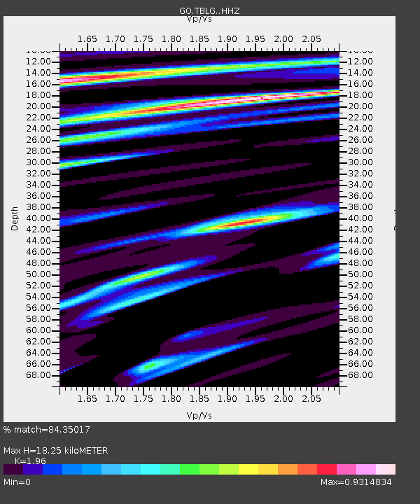
| Estimated Moho Depth: |
18.25 km |
| Estimated Crust Vp/Vs: |
1.96 |
| Assumed Crust Vp: |
6.291 km/s |
| Estimated Crust Vs: |
3.21 km/s |
| Estimated Crust Poisson's Ratio: |
0.32 |
|
| Radial Match: |
84.35017 % |
| Radial Bump: |
386 |
| Transverse Match: |
69.591225 % |
| Transverse Bump: |
400 |
| SOD ConfigId: |
20906531 |
| Insert Time: |
2020-04-09 15:45:12.130 +0000 |
| GWidth: |
2.5 |
| Max Bumps: |
400 |
| Tol: |
0.001 |
|
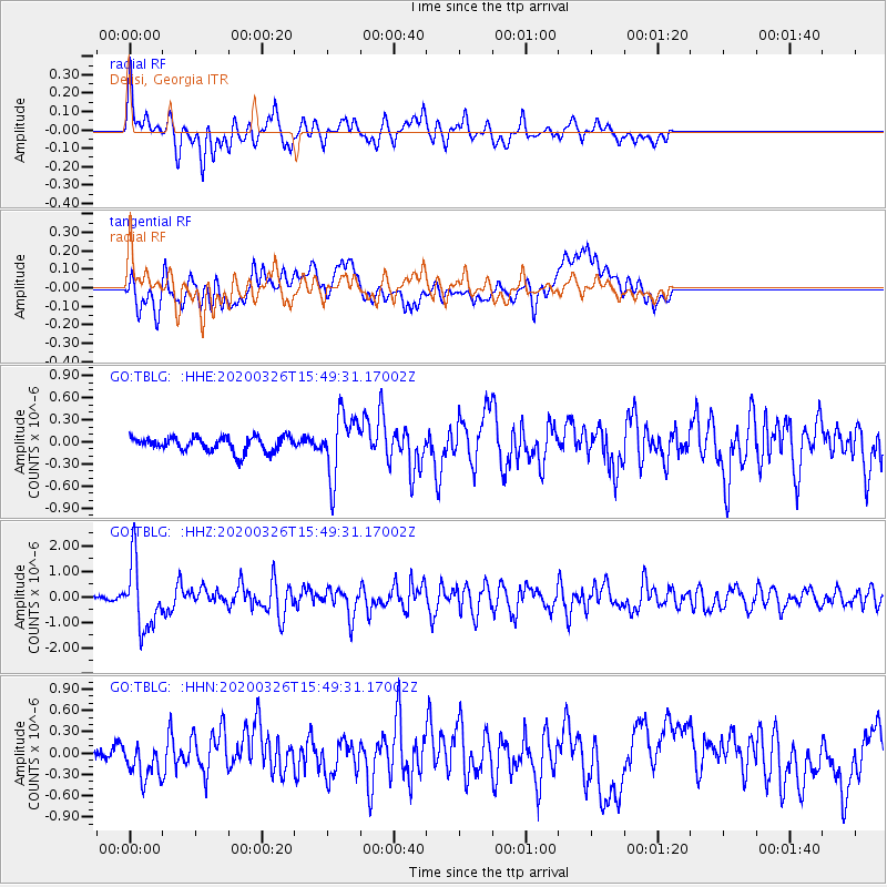
Signal To Noise
| Channel | StoN | STA | LTA |
| GO:TBLG: :HHZ:20200326T15:49:31.17002Z | 12.06978 | 1.289254E-6 | 1.0681669E-7 |
| GO:TBLG: :HHN:20200326T15:49:31.17002Z | 3.1505444 | 2.6263302E-7 | 8.336115E-8 |
| GO:TBLG: :HHE:20200326T15:49:31.17002Z | 4.173324 | 4.2413552E-7 | 1.01630135E-7 |
| Arrivals |
| Ps | 2.9 SECOND |
| PpPs | 8.4 SECOND |
| PsPs/PpSs | 11 SECOND |


