You are here: Home > Network List > TS - TERRAscope (Southern California Seismic Network) Stations List
> Station RPV Rancho Palos Verde California, USA > Earthquake Result Viewer
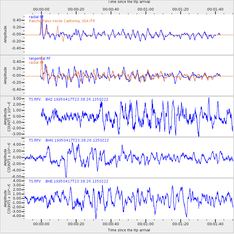
RPV Rancho Palos Verde California, USA - Earthquake Result Viewer
*The percent match for this event was below the threshold and hence no stack was calculated.
| Earthquake location: |
Kuril Islands |
| Earthquake latitude/longitude: |
45.9/151.3 |
| Earthquake time(UTC): |
1995/04/17 (107) 23:28:08 GMT |
| Earthquake Depth: |
34 km |
| Earthquake Magnitude: |
6.1 MB, 6.3 MS, 6.2 UNKNOWN, 6.8 MW |
| Earthquake Catalog/Contributor: |
WHDF/NEIC |
|
| Network: |
TS TERRAscope (Southern California Seismic Network) |
| Station: |
RPV Rancho Palos Verde California, USA |
| Lat/Lon: |
33.74 N/118.40 W |
| Elevation: |
115 m |
|
| Distance: |
66.9 deg |
| Az: |
64.958 deg |
| Baz: |
310.603 deg |
| Ray Param: |
$rayparam |
*The percent match for this event was below the threshold and hence was not used in the summary stack. |
|
| Radial Match: |
74.793846 % |
| Radial Bump: |
400 |
| Transverse Match: |
84.2378 % |
| Transverse Bump: |
400 |
| SOD ConfigId: |
4480 |
| Insert Time: |
2010-02-26 14:45:42.842 +0000 |
| GWidth: |
2.5 |
| Max Bumps: |
400 |
| Tol: |
0.001 |
|
Signal To Noise
| Channel | StoN | STA | LTA |
| TS:RPV: :BHN:19950417T23:38:26.135022Z | 3.6479497 | 1.5681586E-6 | 4.2987398E-7 |
| TS:RPV: :BHE:19950417T23:38:26.135022Z | 1.2341117 | 8.732409E-7 | 7.075866E-7 |
| TS:RPV: :BHZ:19950417T23:38:26.135022Z | 1.7754964 | 9.778378E-7 | 5.5074054E-7 |
| Arrivals |
| Ps | |
| PpPs | |
| PsPs/PpSs | |


