You are here: Home > Network List > TA - USArray Transportable Network (new EarthScope stations) Stations List
> Station E18K Tukpahlearik Creek, AK, USA > Earthquake Result Viewer
E18K Tukpahlearik Creek, AK, USA - Earthquake Result Viewer
| Earthquake location: |
Mindanao, Philippines |
| Earthquake latitude/longitude: |
5.6/125.1 |
| Earthquake time(UTC): |
2020/03/26 (086) 15:38:04 GMT |
| Earthquake Depth: |
59 km |
| Earthquake Magnitude: |
6.1 mww |
| Earthquake Catalog/Contributor: |
NEIC PDE/us |
|
| Network: |
TA USArray Transportable Network (new EarthScope stations) |
| Station: |
E18K Tukpahlearik Creek, AK, USA |
| Lat/Lon: |
67.42 N/160.60 W |
| Elevation: |
297 m |
|
| Distance: |
78.9 deg |
| Az: |
22.268 deg |
| Baz: |
257.613 deg |
| Ray Param: |
0.04922635 |
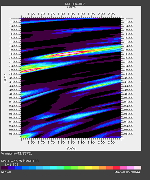
| Estimated Moho Depth: |
27.75 km |
| Estimated Crust Vp/Vs: |
1.83 |
| Assumed Crust Vp: |
6.276 km/s |
| Estimated Crust Vs: |
3.439 km/s |
| Estimated Crust Poisson's Ratio: |
0.29 |
|
| Radial Match: |
92.35751 % |
| Radial Bump: |
400 |
| Transverse Match: |
83.66332 % |
| Transverse Bump: |
400 |
| SOD ConfigId: |
20906531 |
| Insert Time: |
2020-04-09 15:49:29.698 +0000 |
| GWidth: |
2.5 |
| Max Bumps: |
400 |
| Tol: |
0.001 |
|
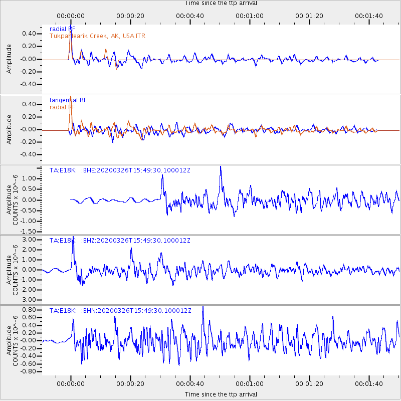
Signal To Noise
| Channel | StoN | STA | LTA |
| TA:E18K: :BHZ:20200326T15:49:30.100012Z | 11.6131525 | 1.1900144E-6 | 1.0247127E-7 |
| TA:E18K: :BHN:20200326T15:49:30.100012Z | 4.2695775 | 2.5505318E-7 | 5.973734E-8 |
| TA:E18K: :BHE:20200326T15:49:30.100012Z | 5.8391848 | 4.3532637E-7 | 7.455259E-8 |
| Arrivals |
| Ps | 3.7 SECOND |
| PpPs | 12 SECOND |
| PsPs/PpSs | 16 SECOND |


