You are here: Home > Network List > TA - USArray Transportable Network (new EarthScope stations) Stations List
> Station E19K Redstone River, AK, USA > Earthquake Result Viewer
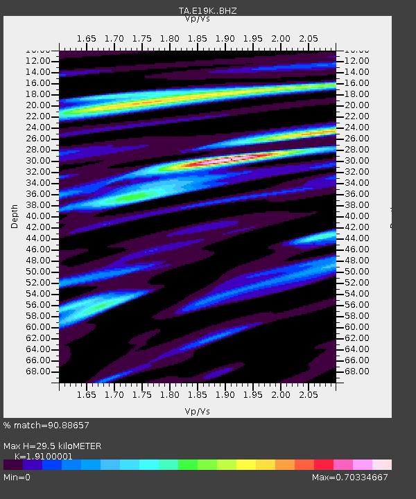
E19K Redstone River, AK, USA - Earthquake Result Viewer
| Earthquake location: |
Mindanao, Philippines |
| Earthquake latitude/longitude: |
5.6/125.1 |
| Earthquake time(UTC): |
2020/03/26 (086) 15:38:04 GMT |
| Earthquake Depth: |
59 km |
| Earthquake Magnitude: |
6.1 mww |
| Earthquake Catalog/Contributor: |
NEIC PDE/us |
|
| Network: |
TA USArray Transportable Network (new EarthScope stations) |
| Station: |
E19K Redstone River, AK, USA |
| Lat/Lon: |
67.46 N/157.23 W |
| Elevation: |
441 m |
|
| Distance: |
80.2 deg |
| Az: |
22.48 deg |
| Baz: |
260.761 deg |
| Ray Param: |
0.04835096 |
| Estimated Moho Depth: |
29.5 km |
| Estimated Crust Vp/Vs: |
1.91 |
| Assumed Crust Vp: |
6.577 km/s |
| Estimated Crust Vs: |
3.443 km/s |
| Estimated Crust Poisson's Ratio: |
0.31 |
|
| Radial Match: |
90.88657 % |
| Radial Bump: |
400 |
| Transverse Match: |
81.4862 % |
| Transverse Bump: |
400 |
| SOD ConfigId: |
20906531 |
| Insert Time: |
2020-04-09 15:49:30.813 +0000 |
| GWidth: |
2.5 |
| Max Bumps: |
400 |
| Tol: |
0.001 |
|

Signal To Noise
| Channel | StoN | STA | LTA |
| TA:E19K: :BHZ:20200326T15:49:37.025Z | 17.697174 | 1.5621761E-6 | 8.827262E-8 |
| TA:E19K: :BHN:20200326T15:49:37.025Z | 3.5898201 | 3.2411816E-7 | 9.028813E-8 |
| TA:E19K: :BHE:20200326T15:49:37.025Z | 8.689037 | 5.635975E-7 | 6.486306E-8 |
| Arrivals |
| Ps | 4.2 SECOND |
| PpPs | 13 SECOND |
| PsPs/PpSs | 17 SECOND |


