You are here: Home > Network List > TA - USArray Transportable Network (new EarthScope stations) Stations List
> Station E20K Nigu River, AK, USA > Earthquake Result Viewer
E20K Nigu River, AK, USA - Earthquake Result Viewer
| Earthquake location: |
Mindanao, Philippines |
| Earthquake latitude/longitude: |
5.6/125.1 |
| Earthquake time(UTC): |
2020/03/26 (086) 15:38:04 GMT |
| Earthquake Depth: |
59 km |
| Earthquake Magnitude: |
6.1 mww |
| Earthquake Catalog/Contributor: |
NEIC PDE/us |
|
| Network: |
TA USArray Transportable Network (new EarthScope stations) |
| Station: |
E20K Nigu River, AK, USA |
| Lat/Lon: |
68.26 N/156.19 W |
| Elevation: |
866 m |
|
| Distance: |
80.7 deg |
| Az: |
21.735 deg |
| Baz: |
261.603 deg |
| Ray Param: |
0.04799935 |
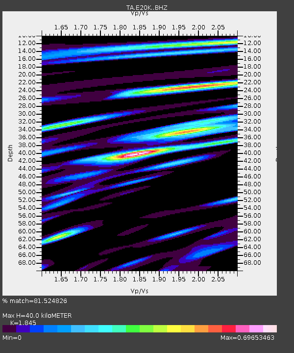
| Estimated Moho Depth: |
40.0 km |
| Estimated Crust Vp/Vs: |
1.85 |
| Assumed Crust Vp: |
6.221 km/s |
| Estimated Crust Vs: |
3.372 km/s |
| Estimated Crust Poisson's Ratio: |
0.29 |
|
| Radial Match: |
81.524826 % |
| Radial Bump: |
400 |
| Transverse Match: |
77.96124 % |
| Transverse Bump: |
400 |
| SOD ConfigId: |
20906531 |
| Insert Time: |
2020-04-09 15:49:32.623 +0000 |
| GWidth: |
2.5 |
| Max Bumps: |
400 |
| Tol: |
0.001 |
|

Signal To Noise
| Channel | StoN | STA | LTA |
| TA:E20K: :BHZ:20200326T15:49:39.775Z | 12.084202 | 1.2635398E-6 | 1.045613E-7 |
| TA:E20K: :BHN:20200326T15:49:39.775Z | 1.1972553 | 1.0741874E-7 | 8.9720835E-8 |
| TA:E20K: :BHE:20200326T15:49:39.775Z | 4.377111 | 4.198793E-7 | 9.592613E-8 |
| Arrivals |
| Ps | 5.6 SECOND |
| PpPs | 18 SECOND |
| PsPs/PpSs | 23 SECOND |


