You are here: Home > Network List > TA - USArray Transportable Network (new EarthScope stations) Stations List
> Station H19K Roundabout Mountain, AK, USA > Earthquake Result Viewer
H19K Roundabout Mountain, AK, USA - Earthquake Result Viewer
| Earthquake location: |
Mindanao, Philippines |
| Earthquake latitude/longitude: |
5.6/125.1 |
| Earthquake time(UTC): |
2020/03/26 (086) 15:38:04 GMT |
| Earthquake Depth: |
59 km |
| Earthquake Magnitude: |
6.1 mww |
| Earthquake Catalog/Contributor: |
NEIC PDE/us |
|
| Network: |
TA USArray Transportable Network (new EarthScope stations) |
| Station: |
H19K Roundabout Mountain, AK, USA |
| Lat/Lon: |
65.53 N/156.45 W |
| Elevation: |
107 m |
|
| Distance: |
80.2 deg |
| Az: |
24.473 deg |
| Baz: |
261.818 deg |
| Ray Param: |
0.048339356 |
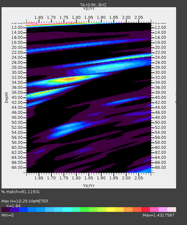
| Estimated Moho Depth: |
10.25 km |
| Estimated Crust Vp/Vs: |
1.64 |
| Assumed Crust Vp: |
6.182 km/s |
| Estimated Crust Vs: |
3.77 km/s |
| Estimated Crust Poisson's Ratio: |
0.20 |
|
| Radial Match: |
91.11931 % |
| Radial Bump: |
400 |
| Transverse Match: |
79.98962 % |
| Transverse Bump: |
400 |
| SOD ConfigId: |
20906531 |
| Insert Time: |
2020-04-09 15:50:28.865 +0000 |
| GWidth: |
2.5 |
| Max Bumps: |
400 |
| Tol: |
0.001 |
|

Signal To Noise
| Channel | StoN | STA | LTA |
| TA:H19K: :BHZ:20200326T15:49:37.124976Z | 42.43369 | 1.8370575E-6 | 4.329243E-8 |
| TA:H19K: :BHN:20200326T15:49:37.124976Z | 2.6769733 | 3.6050548E-7 | 1.3466905E-7 |
| TA:H19K: :BHE:20200326T15:49:37.124976Z | 7.7581267 | 6.504078E-7 | 8.383568E-8 |
| Arrivals |
| Ps | 1.1 SECOND |
| PpPs | 4.3 SECOND |
| PsPs/PpSs | 5.3 SECOND |


