You are here: Home > Network List > TA - USArray Transportable Network (new EarthScope stations) Stations List
> Station J18K Innoko River, AK, USA > Earthquake Result Viewer
J18K Innoko River, AK, USA - Earthquake Result Viewer
| Earthquake location: |
Mindanao, Philippines |
| Earthquake latitude/longitude: |
5.6/125.1 |
| Earthquake time(UTC): |
2020/03/26 (086) 15:38:04 GMT |
| Earthquake Depth: |
59 km |
| Earthquake Magnitude: |
6.1 mww |
| Earthquake Catalog/Contributor: |
NEIC PDE/us |
|
| Network: |
TA USArray Transportable Network (new EarthScope stations) |
| Station: |
J18K Innoko River, AK, USA |
| Lat/Lon: |
63.47 N/156.72 W |
| Elevation: |
506 m |
|
| Distance: |
79.8 deg |
| Az: |
26.538 deg |
| Baz: |
261.937 deg |
| Ray Param: |
0.048619512 |
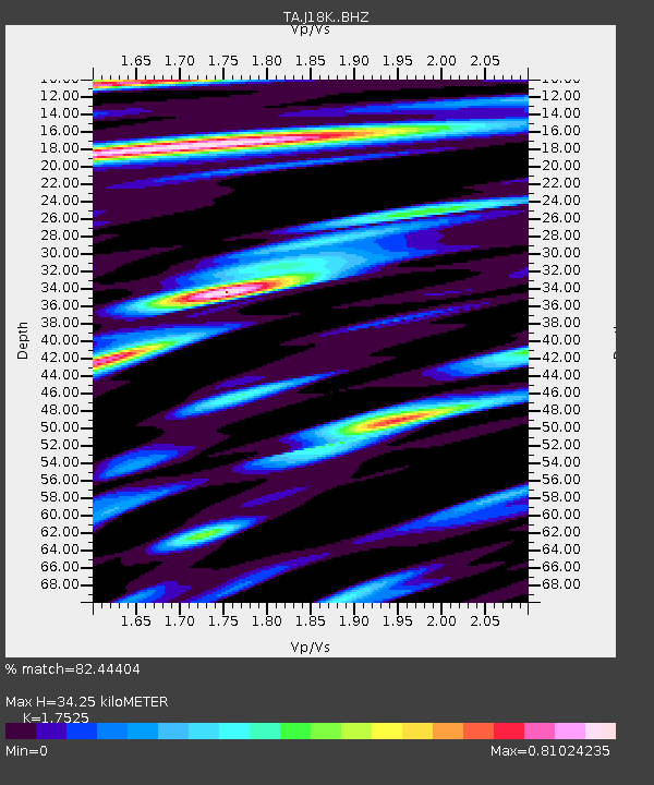
| Estimated Moho Depth: |
34.25 km |
| Estimated Crust Vp/Vs: |
1.75 |
| Assumed Crust Vp: |
6.182 km/s |
| Estimated Crust Vs: |
3.528 km/s |
| Estimated Crust Poisson's Ratio: |
0.26 |
|
| Radial Match: |
82.44404 % |
| Radial Bump: |
400 |
| Transverse Match: |
75.065674 % |
| Transverse Bump: |
400 |
| SOD ConfigId: |
20906531 |
| Insert Time: |
2020-04-09 15:50:45.935 +0000 |
| GWidth: |
2.5 |
| Max Bumps: |
400 |
| Tol: |
0.001 |
|

Signal To Noise
| Channel | StoN | STA | LTA |
| TA:J18K: :BHZ:20200326T15:49:34.949988Z | 11.513178 | 1.0796643E-6 | 9.37764E-8 |
| TA:J18K: :BHN:20200326T15:49:34.949988Z | 1.8654445 | 1.5628285E-7 | 8.377781E-8 |
| TA:J18K: :BHE:20200326T15:49:34.949988Z | 4.234341 | 3.705691E-7 | 8.751517E-8 |
| Arrivals |
| Ps | 4.3 SECOND |
| PpPs | 15 SECOND |
| PsPs/PpSs | 19 SECOND |


