You are here: Home > Network List > GT - Global Telemetered Seismograph Network (USAF/USGS) Stations List
> Station BOSA Boshof, South Africa > Earthquake Result Viewer
BOSA Boshof, South Africa - Earthquake Result Viewer
| Earthquake location: |
South Sandwich Islands Region |
| Earthquake latitude/longitude: |
-56.3/-25.5 |
| Earthquake time(UTC): |
2017/05/10 (130) 23:23:39 GMT |
| Earthquake Depth: |
41 km |
| Earthquake Magnitude: |
6.8 Mi |
| Earthquake Catalog/Contributor: |
NEIC PDE/pt |
|
| Network: |
GT Global Telemetered Seismograph Network (USAF/USGS) |
| Station: |
BOSA Boshof, South Africa |
| Lat/Lon: |
28.61 S/25.26 E |
| Elevation: |
1280 m |
|
| Distance: |
45.1 deg |
| Az: |
73.949 deg |
| Baz: |
217.545 deg |
| Ray Param: |
0.07138121 |
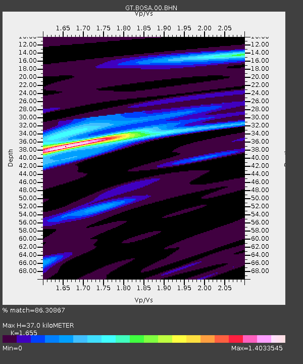
| Estimated Moho Depth: |
37.0 km |
| Estimated Crust Vp/Vs: |
1.65 |
| Assumed Crust Vp: |
6.459 km/s |
| Estimated Crust Vs: |
3.903 km/s |
| Estimated Crust Poisson's Ratio: |
0.21 |
|
| Radial Match: |
86.30867 % |
| Radial Bump: |
268 |
| Transverse Match: |
56.474766 % |
| Transverse Bump: |
400 |
| SOD ConfigId: |
2028011 |
| Insert Time: |
2017-05-24 23:27:23.579 +0000 |
| GWidth: |
2.5 |
| Max Bumps: |
400 |
| Tol: |
0.001 |
|
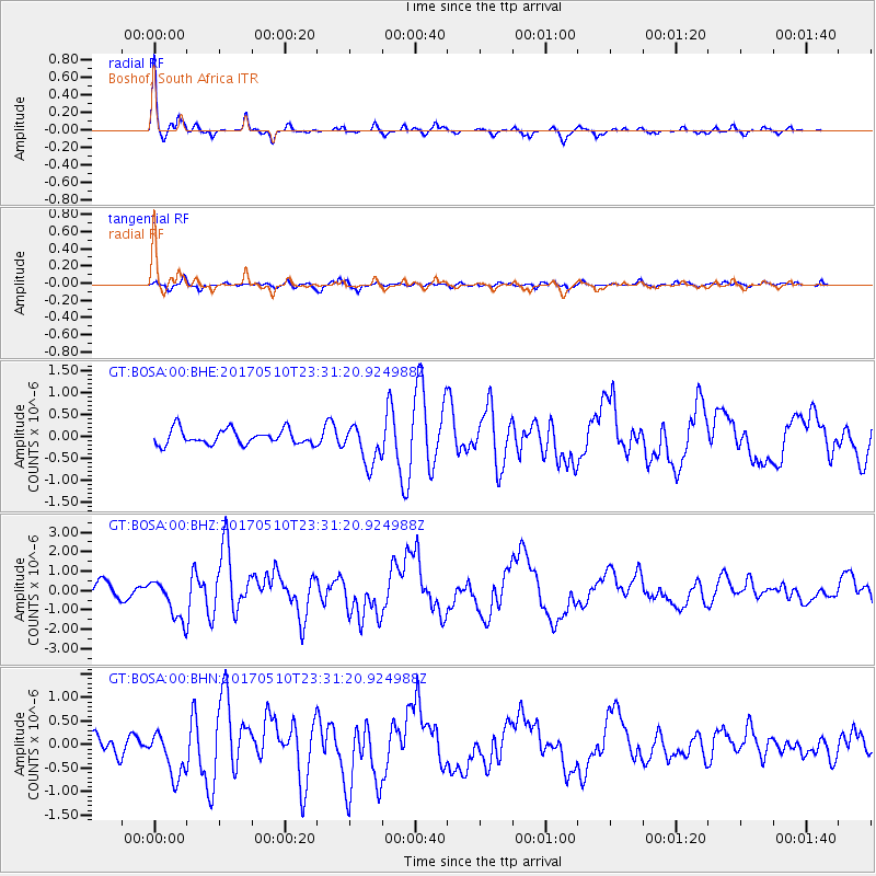
Signal To Noise
| Channel | StoN | STA | LTA |
| GT:BOSA:00:BHZ:20170510T23:31:20.924988Z | 3.4099364 | 1.0480472E-6 | 3.0735094E-7 |
| GT:BOSA:00:BHN:20170510T23:31:20.924988Z | 2.2741518 | 4.84197E-7 | 2.1291325E-7 |
| GT:BOSA:00:BHE:20170510T23:31:20.924988Z | 2.6527808 | 4.5579736E-7 | 1.718187E-7 |
| Arrivals |
| Ps | 4.0 SECOND |
| PpPs | 14 SECOND |
| PsPs/PpSs | 18 SECOND |


