You are here: Home > Network List > TA - USArray Transportable Network (new EarthScope stations) Stations List
> Station O15K Ungalikthiuk River, AK, USA > Earthquake Result Viewer
O15K Ungalikthiuk River, AK, USA - Earthquake Result Viewer
| Earthquake location: |
Mindanao, Philippines |
| Earthquake latitude/longitude: |
5.6/125.1 |
| Earthquake time(UTC): |
2020/03/26 (086) 15:38:04 GMT |
| Earthquake Depth: |
59 km |
| Earthquake Magnitude: |
6.1 mww |
| Earthquake Catalog/Contributor: |
NEIC PDE/us |
|
| Network: |
TA USArray Transportable Network (new EarthScope stations) |
| Station: |
O15K Ungalikthiuk River, AK, USA |
| Lat/Lon: |
59.18 N/159.82 W |
| Elevation: |
306 m |
|
| Distance: |
77.6 deg |
| Az: |
30.631 deg |
| Baz: |
260.014 deg |
| Ray Param: |
0.050091337 |
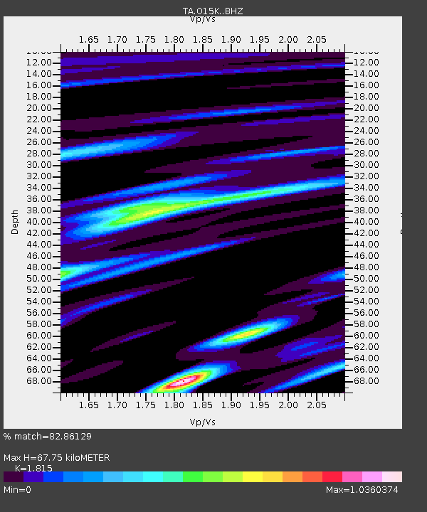
| Estimated Moho Depth: |
67.75 km |
| Estimated Crust Vp/Vs: |
1.82 |
| Assumed Crust Vp: |
6.24 km/s |
| Estimated Crust Vs: |
3.438 km/s |
| Estimated Crust Poisson's Ratio: |
0.28 |
|
| Radial Match: |
82.86129 % |
| Radial Bump: |
400 |
| Transverse Match: |
70.15856 % |
| Transverse Bump: |
400 |
| SOD ConfigId: |
20906531 |
| Insert Time: |
2020-04-09 15:51:33.213 +0000 |
| GWidth: |
2.5 |
| Max Bumps: |
400 |
| Tol: |
0.001 |
|

Signal To Noise
| Channel | StoN | STA | LTA |
| TA:O15K: :BHZ:20200326T15:49:23.150Z | 8.533901 | 9.204415E-7 | 1.0785706E-7 |
| TA:O15K: :BHN:20200326T15:49:23.150Z | 2.139235 | 1.6793922E-7 | 7.850434E-8 |
| TA:O15K: :BHE:20200326T15:49:23.150Z | 5.3761253 | 4.0206635E-7 | 7.478738E-8 |
| Arrivals |
| Ps | 9.1 SECOND |
| PpPs | 30 SECOND |
| PsPs/PpSs | 39 SECOND |


