You are here: Home > Network List > TA - USArray Transportable Network (new EarthScope stations) Stations List
> Station R33M Jennings River, BC, CAN > Earthquake Result Viewer
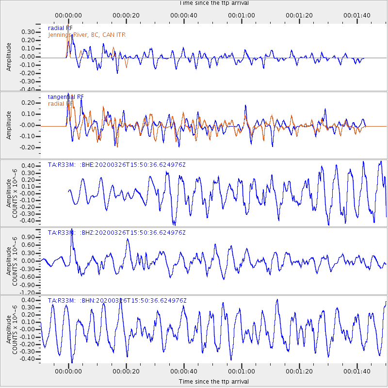
R33M Jennings River, BC, CAN - Earthquake Result Viewer
*The percent match for this event was below the threshold and hence no stack was calculated.
| Earthquake location: |
Mindanao, Philippines |
| Earthquake latitude/longitude: |
5.6/125.1 |
| Earthquake time(UTC): |
2020/03/26 (086) 15:38:04 GMT |
| Earthquake Depth: |
59 km |
| Earthquake Magnitude: |
6.1 mww |
| Earthquake Catalog/Contributor: |
NEIC PDE/us |
|
| Network: |
TA USArray Transportable Network (new EarthScope stations) |
| Station: |
R33M Jennings River, BC, CAN |
| Lat/Lon: |
59.39 N/130.97 W |
| Elevation: |
1437 m |
|
| Distance: |
92.3 deg |
| Az: |
29.795 deg |
| Baz: |
284.843 deg |
| Ray Param: |
$rayparam |
*The percent match for this event was below the threshold and hence was not used in the summary stack. |
|
| Radial Match: |
65.868675 % |
| Radial Bump: |
400 |
| Transverse Match: |
58.528065 % |
| Transverse Bump: |
400 |
| SOD ConfigId: |
20906531 |
| Insert Time: |
2020-04-09 15:51:57.161 +0000 |
| GWidth: |
2.5 |
| Max Bumps: |
400 |
| Tol: |
0.001 |
|
Signal To Noise
| Channel | StoN | STA | LTA |
| TA:R33M: :BHZ:20200326T15:50:36.624976Z | 4.05329 | 4.5614297E-7 | 1.1253648E-7 |
| TA:R33M: :BHN:20200326T15:50:36.624976Z | 1.0753158 | 2.3419015E-7 | 2.177873E-7 |
| TA:R33M: :BHE:20200326T15:50:36.624976Z | 1.7373805 | 1.7455245E-7 | 1.0046875E-7 |
| Arrivals |
| Ps | |
| PpPs | |
| PsPs/PpSs | |


