You are here: Home > Network List > GT - Global Telemetered Seismograph Network (USAF/USGS) Stations List
> Station CPUP Villa Florida, Paraguay > Earthquake Result Viewer
CPUP Villa Florida, Paraguay - Earthquake Result Viewer
| Earthquake location: |
South Sandwich Islands Region |
| Earthquake latitude/longitude: |
-56.3/-25.5 |
| Earthquake time(UTC): |
2017/05/10 (130) 23:23:39 GMT |
| Earthquake Depth: |
41 km |
| Earthquake Magnitude: |
6.8 Mi |
| Earthquake Catalog/Contributor: |
NEIC PDE/pt |
|
| Network: |
GT Global Telemetered Seismograph Network (USAF/USGS) |
| Station: |
CPUP Villa Florida, Paraguay |
| Lat/Lon: |
26.33 S/57.33 W |
| Elevation: |
105 m |
|
| Distance: |
37.7 deg |
| Az: |
309.295 deg |
| Baz: |
151.264 deg |
| Ray Param: |
0.07590356 |
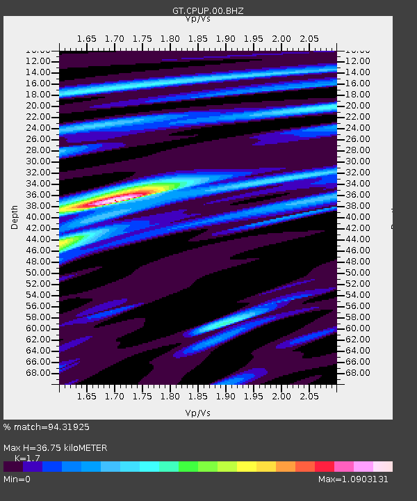
| Estimated Moho Depth: |
36.75 km |
| Estimated Crust Vp/Vs: |
1.70 |
| Assumed Crust Vp: |
6.498 km/s |
| Estimated Crust Vs: |
3.822 km/s |
| Estimated Crust Poisson's Ratio: |
0.24 |
|
| Radial Match: |
94.31925 % |
| Radial Bump: |
260 |
| Transverse Match: |
74.73748 % |
| Transverse Bump: |
400 |
| SOD ConfigId: |
2028011 |
| Insert Time: |
2017-05-24 23:27:31.366 +0000 |
| GWidth: |
2.5 |
| Max Bumps: |
400 |
| Tol: |
0.001 |
|
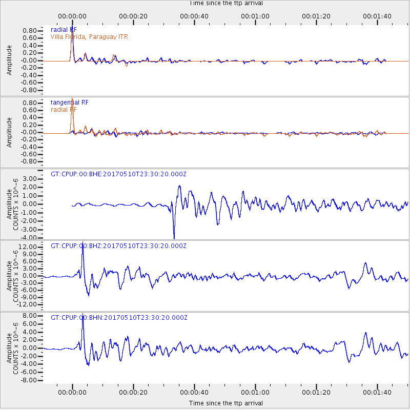
Signal To Noise
| Channel | StoN | STA | LTA |
| GT:CPUP:00:BHZ:20170510T23:30:20.000Z | 26.982878 | 4.2307033E-6 | 1.5679215E-7 |
| GT:CPUP:00:BHN:20170510T23:30:20.000Z | 25.661316 | 2.5942509E-6 | 1.01095786E-7 |
| GT:CPUP:00:BHE:20170510T23:30:20.000Z | 10.819943 | 1.1809208E-6 | 1.09142974E-7 |
| Arrivals |
| Ps | 4.3 SECOND |
| PpPs | 14 SECOND |
| PsPs/PpSs | 18 SECOND |


