You are here: Home > Network List > GT - Global Telemetered Seismograph Network (USAF/USGS) Stations List
> Station LPAZ La Paz , Bolivia > Earthquake Result Viewer
LPAZ La Paz , Bolivia - Earthquake Result Viewer
| Earthquake location: |
South Sandwich Islands Region |
| Earthquake latitude/longitude: |
-56.3/-25.5 |
| Earthquake time(UTC): |
2017/05/10 (130) 23:23:39 GMT |
| Earthquake Depth: |
41 km |
| Earthquake Magnitude: |
6.8 Mi |
| Earthquake Catalog/Contributor: |
NEIC PDE/pt |
|
| Network: |
GT Global Telemetered Seismograph Network (USAF/USGS) |
| Station: |
LPAZ La Paz , Bolivia |
| Lat/Lon: |
16.17 S/68.08 W |
| Elevation: |
4817 m |
|
| Distance: |
51.4 deg |
| Az: |
303.688 deg |
| Baz: |
151.135 deg |
| Ray Param: |
0.06737368 |
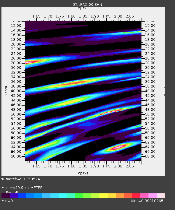
| Estimated Moho Depth: |
49.0 km |
| Estimated Crust Vp/Vs: |
1.96 |
| Assumed Crust Vp: |
6.454 km/s |
| Estimated Crust Vs: |
3.293 km/s |
| Estimated Crust Poisson's Ratio: |
0.32 |
|
| Radial Match: |
93.358574 % |
| Radial Bump: |
400 |
| Transverse Match: |
90.642 % |
| Transverse Bump: |
400 |
| SOD ConfigId: |
2028011 |
| Insert Time: |
2017-05-24 23:27:33.873 +0000 |
| GWidth: |
2.5 |
| Max Bumps: |
400 |
| Tol: |
0.001 |
|

Signal To Noise
| Channel | StoN | STA | LTA |
| GT:LPAZ:00:BHZ:20170510T23:32:08.324005Z | 94.56427 | 6.0025195E-6 | 6.347556E-8 |
| GT:LPAZ:00:BHN:20170510T23:32:08.324005Z | 25.613073 | 1.8962695E-6 | 7.403522E-8 |
| GT:LPAZ:00:BHE:20170510T23:32:08.324005Z | 21.18703 | 1.7291366E-6 | 8.1612974E-8 |
| Arrivals |
| Ps | 7.7 SECOND |
| PpPs | 21 SECOND |
| PsPs/PpSs | 29 SECOND |


