You are here: Home > Network List > G - GEOSCOPE Stations List
> Station MPG Montagne des Peres, French Guyana > Earthquake Result Viewer
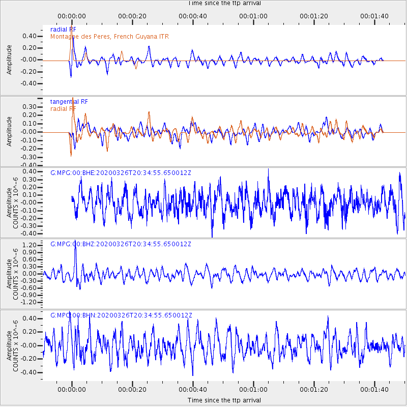
MPG Montagne des Peres, French Guyana - Earthquake Result Viewer
*The percent match for this event was below the threshold and hence no stack was calculated.
| Earthquake location: |
South Sandwich Islands Region |
| Earthquake latitude/longitude: |
-56.6/-26.9 |
| Earthquake time(UTC): |
2020/03/26 (086) 20:24:54 GMT |
| Earthquake Depth: |
78 km |
| Earthquake Magnitude: |
5.4 Mww |
| Earthquake Catalog/Contributor: |
NEIC PDE/us |
|
| Network: |
G GEOSCOPE |
| Station: |
MPG Montagne des Peres, French Guyana |
| Lat/Lon: |
5.11 N/52.64 W |
| Elevation: |
147 m |
|
| Distance: |
65.0 deg |
| Az: |
331.481 deg |
| Baz: |
164.63 deg |
| Ray Param: |
$rayparam |
*The percent match for this event was below the threshold and hence was not used in the summary stack. |
|
| Radial Match: |
64.46045 % |
| Radial Bump: |
400 |
| Transverse Match: |
55.315968 % |
| Transverse Bump: |
400 |
| SOD ConfigId: |
20906531 |
| Insert Time: |
2020-04-09 20:27:09.051 +0000 |
| GWidth: |
2.5 |
| Max Bumps: |
400 |
| Tol: |
0.001 |
|
Signal To Noise
| Channel | StoN | STA | LTA |
| G:MPG:00:BHZ:20200326T20:34:55.650012Z | 2.6794326 | 4.5529433E-7 | 1.6992192E-7 |
| G:MPG:00:BHN:20200326T20:34:55.650012Z | 1.8615075 | 2.3589786E-7 | 1.2672409E-7 |
| G:MPG:00:BHE:20200326T20:34:55.650012Z | 0.90320504 | 1.2883045E-7 | 1.4263699E-7 |
| Arrivals |
| Ps | |
| PpPs | |
| PsPs/PpSs | |


