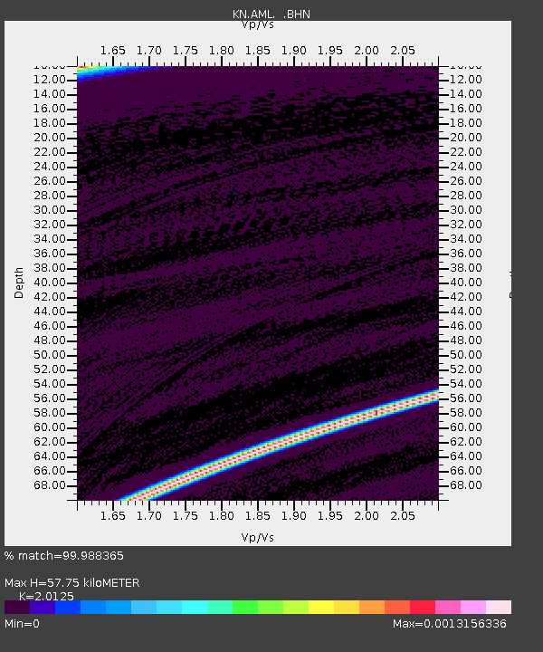
AML KN.AML - Earthquake Result Viewer

Earthquake location: Talaud Islands, Indonesia
Earthquake latitude/longitude: 4.5/127.7
Earthquake time(UTC): 2000/06/14 (166) 17:00:48 GMT
Earthquake Depth: 90 km
Earthquake Magnitude: 6.1 MB, 5.6 MS, 6.4 MW, 6.3 MW
Earthquake Catalog/Contributor: WHDF/NEIC
Network: KN Kyrgyz Seismic Telemetry Network
Station: AML KN.AML
Lat/Lon: 42.13 N/73.69 E
Elevation: 3400 m
Distance: 60.8 deg
Az: 316.388 deg
Baz: 112.419 deg
Ray Param: 0.06105722
Estimated Moho Depth: 57.75 km
Estimated Crust Vp/Vs: 2.01
Assumed Crust Vp: 6.316 km/s
Estimated Crust Vs: 3.138 km/s
Estimated Crust Poisson's Ratio: 0.34
Radial Match: 99.988365 %
Radial Bump: 2
Transverse Match: 99.40354 %
Transverse Bump: 82
SOD ConfigId: 3744
Insert Time: 2010-03-08 18:51:35.216 +0000
GWidth: 2.5
Max Bumps: 400
Tol: 0.001

Signal To Noise

ChannelStoNSTALTA
KN:AML: :BHN:20000614T17:10:20.248999Z0.84037691.4551457E-81.7315392E-8
KN:AML: :BHE:20000614T17:10:20.248999Z18.8023071.339959E-67.1265674E-8
KN:AML: :BHZ:20000614T17:10:20.248999Z18.8467319.571486E-75.078592E-8
Arrivals
Ps9.6 SECOND
PpPs26 SECOND
PsPs/PpSs36 SECOND