You are here: Home > Network List > PS - Pacific21 Stations List
> Station PSI Parapat, Indonesia > Earthquake Result Viewer
PSI Parapat, Indonesia - Earthquake Result Viewer
| Earthquake location: |
Near North Coast Of Irian Jaya |
| Earthquake latitude/longitude: |
-3.0/139.1 |
| Earthquake time(UTC): |
2020/03/26 (086) 21:36:42 GMT |
| Earthquake Depth: |
38 km |
| Earthquake Magnitude: |
5.7 mww |
| Earthquake Catalog/Contributor: |
NEIC PDE/us |
|
| Network: |
PS Pacific21 |
| Station: |
PSI Parapat, Indonesia |
| Lat/Lon: |
2.69 N/98.92 E |
| Elevation: |
987 m |
|
| Distance: |
40.6 deg |
| Az: |
277.568 deg |
| Baz: |
97.661 deg |
| Ray Param: |
0.07424744 |
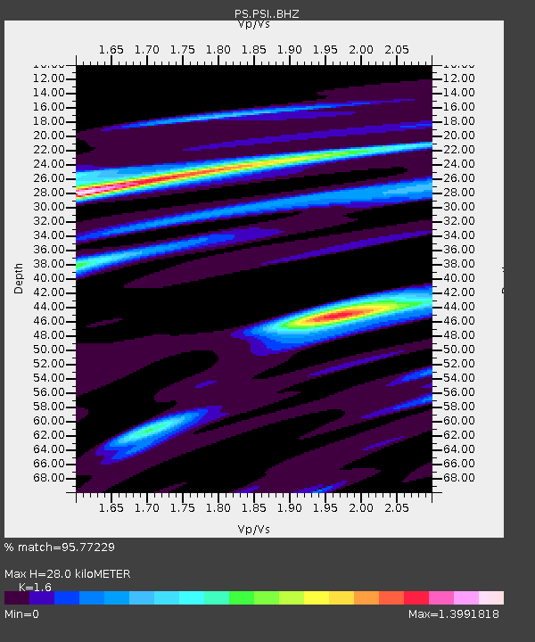
| Estimated Moho Depth: |
28.0 km |
| Estimated Crust Vp/Vs: |
1.60 |
| Assumed Crust Vp: |
6.468 km/s |
| Estimated Crust Vs: |
4.042 km/s |
| Estimated Crust Poisson's Ratio: |
0.18 |
|
| Radial Match: |
95.77229 % |
| Radial Bump: |
388 |
| Transverse Match: |
83.468834 % |
| Transverse Bump: |
400 |
| SOD ConfigId: |
20906531 |
| Insert Time: |
2020-04-09 21:42:24.323 +0000 |
| GWidth: |
2.5 |
| Max Bumps: |
400 |
| Tol: |
0.001 |
|
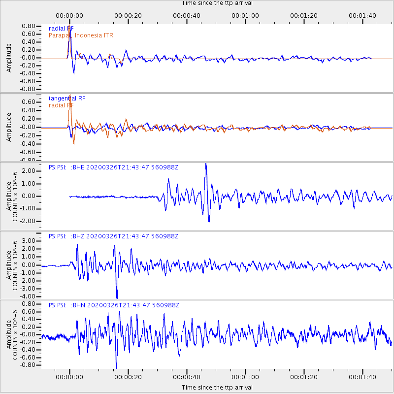
Signal To Noise
| Channel | StoN | STA | LTA |
| PS:PSI: :BHZ:20200326T21:43:47.560988Z | 19.54671 | 9.512786E-7 | 4.8666944E-8 |
| PS:PSI: :BHN:20200326T21:43:47.560988Z | 2.5503073 | 1.7747185E-7 | 6.958842E-8 |
| PS:PSI: :BHE:20200326T21:43:47.560988Z | 17.858435 | 5.614824E-7 | 3.144074E-8 |
| Arrivals |
| Ps | 2.8 SECOND |
| PpPs | 10 SECOND |
| PsPs/PpSs | 13 SECOND |


