You are here: Home > Network List > TA - USArray Transportable Network (new EarthScope stations) Stations List
> Station G21K Allakaket, AK, USA > Earthquake Result Viewer
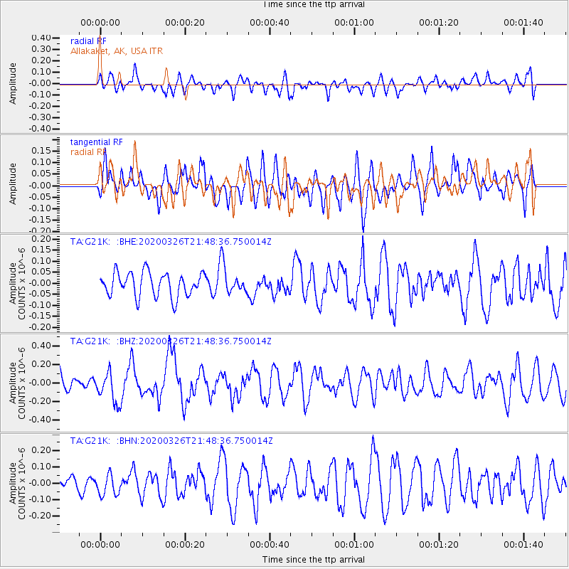
G21K Allakaket, AK, USA - Earthquake Result Viewer
*The percent match for this event was below the threshold and hence no stack was calculated.
| Earthquake location: |
Near North Coast Of Irian Jaya |
| Earthquake latitude/longitude: |
-3.0/139.1 |
| Earthquake time(UTC): |
2020/03/26 (086) 21:36:42 GMT |
| Earthquake Depth: |
38 km |
| Earthquake Magnitude: |
5.7 mww |
| Earthquake Catalog/Contributor: |
NEIC PDE/us |
|
| Network: |
TA USArray Transportable Network (new EarthScope stations) |
| Station: |
G21K Allakaket, AK, USA |
| Lat/Lon: |
66.52 N/153.51 W |
| Elevation: |
446 m |
|
| Distance: |
83.9 deg |
| Az: |
21.843 deg |
| Baz: |
248.004 deg |
| Ray Param: |
$rayparam |
*The percent match for this event was below the threshold and hence was not used in the summary stack. |
|
| Radial Match: |
51.08243 % |
| Radial Bump: |
400 |
| Transverse Match: |
44.938488 % |
| Transverse Bump: |
400 |
| SOD ConfigId: |
20906531 |
| Insert Time: |
2020-04-09 21:43:30.237 +0000 |
| GWidth: |
2.5 |
| Max Bumps: |
400 |
| Tol: |
0.001 |
|
Signal To Noise
| Channel | StoN | STA | LTA |
| TA:G21K: :BHZ:20200326T21:48:36.750014Z | 1.741007 | 1.7102775E-7 | 9.823496E-8 |
| TA:G21K: :BHN:20200326T21:48:36.750014Z | 0.98037946 | 6.381856E-8 | 6.5095776E-8 |
| TA:G21K: :BHE:20200326T21:48:36.750014Z | 0.8502195 | 4.5836355E-8 | 5.3911204E-8 |
| Arrivals |
| Ps | |
| PpPs | |
| PsPs/PpSs | |


