You are here: Home > Network List > TA - USArray Transportable Network (new EarthScope stations) Stations List
> Station I17K Unalakleet, AK, USA > Earthquake Result Viewer
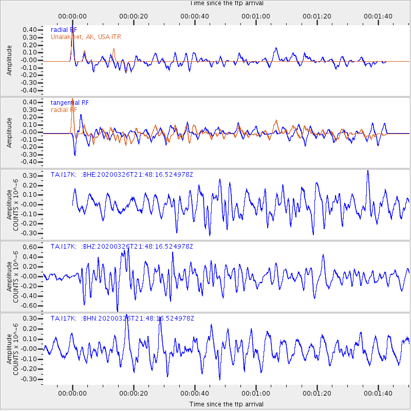
I17K Unalakleet, AK, USA - Earthquake Result Viewer
*The percent match for this event was below the threshold and hence no stack was calculated.
| Earthquake location: |
Near North Coast Of Irian Jaya |
| Earthquake latitude/longitude: |
-3.0/139.1 |
| Earthquake time(UTC): |
2020/03/26 (086) 21:36:42 GMT |
| Earthquake Depth: |
38 km |
| Earthquake Magnitude: |
5.7 mww |
| Earthquake Catalog/Contributor: |
NEIC PDE/us |
|
| Network: |
TA USArray Transportable Network (new EarthScope stations) |
| Station: |
I17K Unalakleet, AK, USA |
| Lat/Lon: |
63.89 N/160.70 W |
| Elevation: |
105 m |
|
| Distance: |
80.0 deg |
| Az: |
22.95 deg |
| Baz: |
241.637 deg |
| Ray Param: |
$rayparam |
*The percent match for this event was below the threshold and hence was not used in the summary stack. |
|
| Radial Match: |
63.484795 % |
| Radial Bump: |
400 |
| Transverse Match: |
71.16518 % |
| Transverse Bump: |
390 |
| SOD ConfigId: |
20906531 |
| Insert Time: |
2020-04-09 21:43:41.535 +0000 |
| GWidth: |
2.5 |
| Max Bumps: |
400 |
| Tol: |
0.001 |
|
Signal To Noise
| Channel | StoN | STA | LTA |
| TA:I17K: :BHZ:20200326T21:48:16.524978Z | 2.1149065 | 1.8879639E-7 | 8.9269385E-8 |
| TA:I17K: :BHN:20200326T21:48:16.524978Z | 0.635021 | 8.314508E-8 | 1.309328E-7 |
| TA:I17K: :BHE:20200326T21:48:16.524978Z | 1.5524014 | 1.0542913E-7 | 6.7913575E-8 |
| Arrivals |
| Ps | |
| PpPs | |
| PsPs/PpSs | |


