You are here: Home > Network List > TS - TERRAscope (Southern California Seismic Network) Stations List
> Station RPV Rancho Palos Verde California, USA > Earthquake Result Viewer
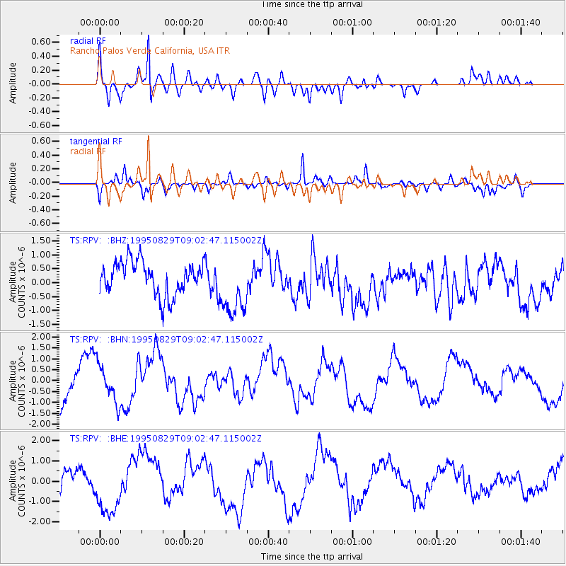
RPV Rancho Palos Verde California, USA - Earthquake Result Viewer
*The percent match for this event was below the threshold and hence no stack was calculated.
| Earthquake location: |
Tonga Islands |
| Earthquake latitude/longitude: |
-20.9/-174.6 |
| Earthquake time(UTC): |
1995/08/29 (241) 08:51:30 GMT |
| Earthquake Depth: |
18 km |
| Earthquake Magnitude: |
5.6 MS, 5.4 MB |
| Earthquake Catalog/Contributor: |
WHDF/NEIC |
|
| Network: |
TS TERRAscope (Southern California Seismic Network) |
| Station: |
RPV Rancho Palos Verde California, USA |
| Lat/Lon: |
33.74 N/118.40 W |
| Elevation: |
115 m |
|
| Distance: |
76.3 deg |
| Az: |
45.458 deg |
| Baz: |
233.097 deg |
| Ray Param: |
$rayparam |
*The percent match for this event was below the threshold and hence was not used in the summary stack. |
|
| Radial Match: |
77.35079 % |
| Radial Bump: |
400 |
| Transverse Match: |
85.73728 % |
| Transverse Bump: |
400 |
| SOD ConfigId: |
4480 |
| Insert Time: |
2010-02-26 14:45:48.531 +0000 |
| GWidth: |
2.5 |
| Max Bumps: |
400 |
| Tol: |
0.001 |
|
Signal To Noise
| Channel | StoN | STA | LTA |
| TS:RPV: :BHN:19950829T09:02:47.115002Z | 0.95435095 | 8.502703E-7 | 8.909409E-7 |
| TS:RPV: :BHE:19950829T09:02:47.115002Z | 1.9680864 | 1.6207065E-6 | 8.2349356E-7 |
| TS:RPV: :BHZ:19950829T09:02:47.115002Z | 1.8846182 | 1.1033188E-6 | 5.854336E-7 |
| Arrivals |
| Ps | |
| PpPs | |
| PsPs/PpSs | |


