You are here: Home > Network List > TA - USArray Transportable Network (new EarthScope stations) Stations List
> Station K13K Kusilvak Mountain, AK, USA > Earthquake Result Viewer
K13K Kusilvak Mountain, AK, USA - Earthquake Result Viewer
| Earthquake location: |
Near North Coast Of Irian Jaya |
| Earthquake latitude/longitude: |
-3.0/139.1 |
| Earthquake time(UTC): |
2020/03/26 (086) 21:36:42 GMT |
| Earthquake Depth: |
38 km |
| Earthquake Magnitude: |
5.7 mww |
| Earthquake Catalog/Contributor: |
NEIC PDE/us |
|
| Network: |
TA USArray Transportable Network (new EarthScope stations) |
| Station: |
K13K Kusilvak Mountain, AK, USA |
| Lat/Lon: |
61.93 N/164.66 W |
| Elevation: |
204 m |
|
| Distance: |
77.4 deg |
| Az: |
23.754 deg |
| Baz: |
238.273 deg |
| Ray Param: |
0.05027173 |
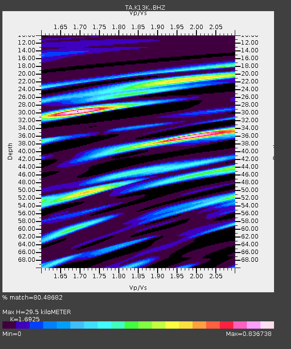
| Estimated Moho Depth: |
29.5 km |
| Estimated Crust Vp/Vs: |
1.69 |
| Assumed Crust Vp: |
6.1 km/s |
| Estimated Crust Vs: |
3.604 km/s |
| Estimated Crust Poisson's Ratio: |
0.23 |
|
| Radial Match: |
80.48682 % |
| Radial Bump: |
400 |
| Transverse Match: |
54.467434 % |
| Transverse Bump: |
400 |
| SOD ConfigId: |
20906531 |
| Insert Time: |
2020-04-09 21:43:48.900 +0000 |
| GWidth: |
2.5 |
| Max Bumps: |
400 |
| Tol: |
0.001 |
|

Signal To Noise
| Channel | StoN | STA | LTA |
| TA:K13K: :BHZ:20200326T21:48:02.575026Z | 2.7682326 | 1.9836138E-7 | 7.165632E-8 |
| TA:K13K: :BHN:20200326T21:48:02.575026Z | 2.0483077 | 1.2250058E-7 | 5.980576E-8 |
| TA:K13K: :BHE:20200326T21:48:02.575026Z | 1.4496263 | 1.060623E-7 | 7.316527E-8 |
| Arrivals |
| Ps | 3.4 SECOND |
| PpPs | 13 SECOND |
| PsPs/PpSs | 16 SECOND |


