You are here: Home > Network List > TS - TERRAscope (Southern California Seismic Network) Stations List
> Station RPV Rancho Palos Verde California, USA > Earthquake Result Viewer
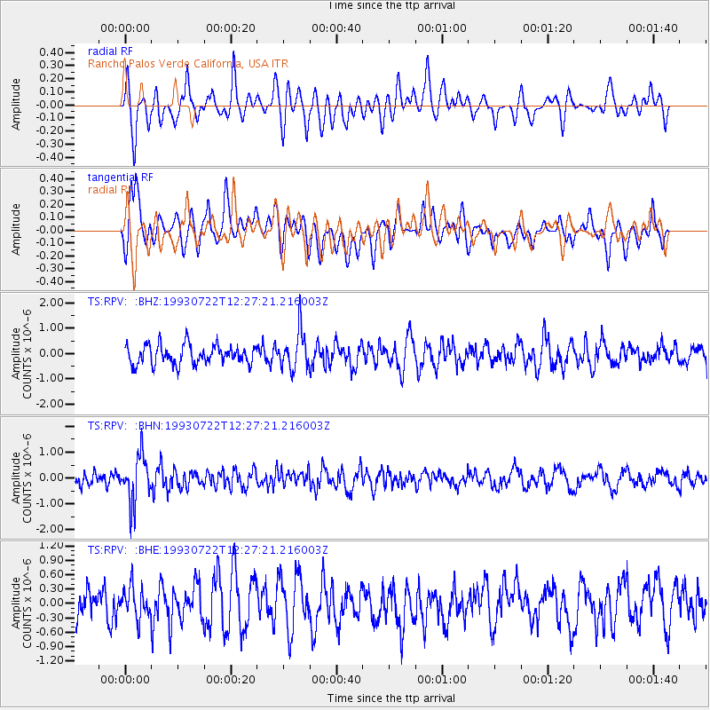
RPV Rancho Palos Verde California, USA - Earthquake Result Viewer
*The percent match for this event was below the threshold and hence no stack was calculated.
| Earthquake location: |
Mariana Islands Region |
| Earthquake latitude/longitude: |
21.8/144.2 |
| Earthquake time(UTC): |
1993/07/22 (203) 12:15:36 GMT |
| Earthquake Depth: |
126 km |
| Earthquake Magnitude: |
5.5 MB, 5.8 UNKNOWN |
| Earthquake Catalog/Contributor: |
WHDF/NEIC |
|
| Network: |
TS TERRAscope (Southern California Seismic Network) |
| Station: |
RPV Rancho Palos Verde California, USA |
| Lat/Lon: |
33.74 N/118.40 W |
| Elevation: |
115 m |
|
| Distance: |
84.0 deg |
| Az: |
56.187 deg |
| Baz: |
292.047 deg |
| Ray Param: |
$rayparam |
*The percent match for this event was below the threshold and hence was not used in the summary stack. |
|
| Radial Match: |
64.40225 % |
| Radial Bump: |
400 |
| Transverse Match: |
61.945805 % |
| Transverse Bump: |
400 |
| SOD ConfigId: |
4480 |
| Insert Time: |
2010-02-26 14:45:50.585 +0000 |
| GWidth: |
2.5 |
| Max Bumps: |
400 |
| Tol: |
0.001 |
|
Signal To Noise
| Channel | StoN | STA | LTA |
| TS:RPV: :BHN:19930722T12:27:21.216003Z | 4.3987875 | 9.017263E-7 | 2.0499428E-7 |
| TS:RPV: :BHE:19930722T12:27:21.216003Z | 0.93246514 | 3.2566572E-7 | 3.4925242E-7 |
| TS:RPV: :BHZ:19930722T12:27:21.216003Z | 2.0375383 | 7.638452E-7 | 3.748863E-7 |
| Arrivals |
| Ps | |
| PpPs | |
| PsPs/PpSs | |


