You are here: Home > Network List > TA - USArray Transportable Network (new EarthScope stations) Stations List
> Station H16K Elim, AK, USA > Earthquake Result Viewer
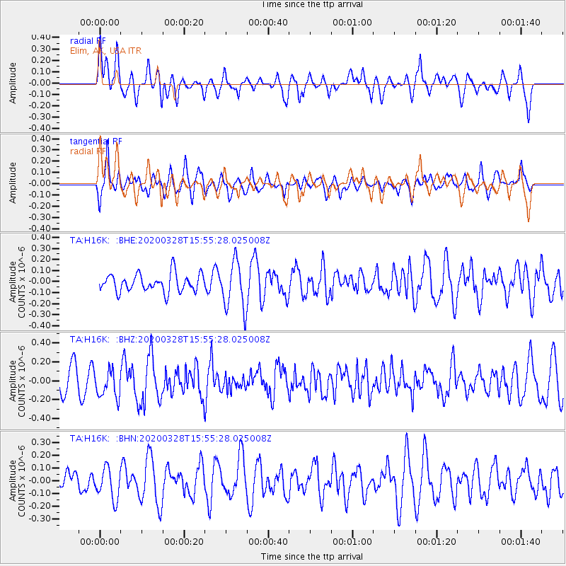
H16K Elim, AK, USA - Earthquake Result Viewer
*The percent match for this event was below the threshold and hence no stack was calculated.
| Earthquake location: |
Sulawesi, Indonesia |
| Earthquake latitude/longitude: |
-1.8/120.2 |
| Earthquake time(UTC): |
2020/03/28 (088) 15:43:17 GMT |
| Earthquake Depth: |
10 km |
| Earthquake Magnitude: |
5.8 Mww |
| Earthquake Catalog/Contributor: |
NEIC PDE/us |
|
| Network: |
TA USArray Transportable Network (new EarthScope stations) |
| Station: |
H16K Elim, AK, USA |
| Lat/Lon: |
64.64 N/162.24 W |
| Elevation: |
216 m |
|
| Distance: |
86.3 deg |
| Az: |
24.929 deg |
| Baz: |
258.008 deg |
| Ray Param: |
$rayparam |
*The percent match for this event was below the threshold and hence was not used in the summary stack. |
|
| Radial Match: |
67.97103 % |
| Radial Bump: |
400 |
| Transverse Match: |
59.961746 % |
| Transverse Bump: |
400 |
| SOD ConfigId: |
20906531 |
| Insert Time: |
2020-04-11 15:48:55.370 +0000 |
| GWidth: |
2.5 |
| Max Bumps: |
400 |
| Tol: |
0.001 |
|
Signal To Noise
| Channel | StoN | STA | LTA |
| TA:H16K: :BHZ:20200328T15:55:28.025008Z | 1.000872 | 1.5126108E-7 | 1.5112927E-7 |
| TA:H16K: :BHN:20200328T15:55:28.025008Z | 1.6385093 | 1.25277E-7 | 7.6457916E-8 |
| TA:H16K: :BHE:20200328T15:55:28.025008Z | 2.757851 | 2.2254787E-7 | 8.0696125E-8 |
| Arrivals |
| Ps | |
| PpPs | |
| PsPs/PpSs | |


