You are here: Home > Network List > TJ - Tajikistan National Seismic Network Stations List
> Station GARM Garm, Tajikistan > Earthquake Result Viewer
GARM Garm, Tajikistan - Earthquake Result Viewer
| Earthquake location: |
Sulawesi, Indonesia |
| Earthquake latitude/longitude: |
-1.8/120.2 |
| Earthquake time(UTC): |
2020/03/28 (088) 15:43:17 GMT |
| Earthquake Depth: |
10 km |
| Earthquake Magnitude: |
5.8 Mww |
| Earthquake Catalog/Contributor: |
NEIC PDE/us |
|
| Network: |
TJ Tajikistan National Seismic Network |
| Station: |
GARM Garm, Tajikistan |
| Lat/Lon: |
39.00 N/70.32 E |
| Elevation: |
1305 m |
|
| Distance: |
61.1 deg |
| Az: |
317.135 deg |
| Baz: |
119.235 deg |
| Ray Param: |
0.061077237 |
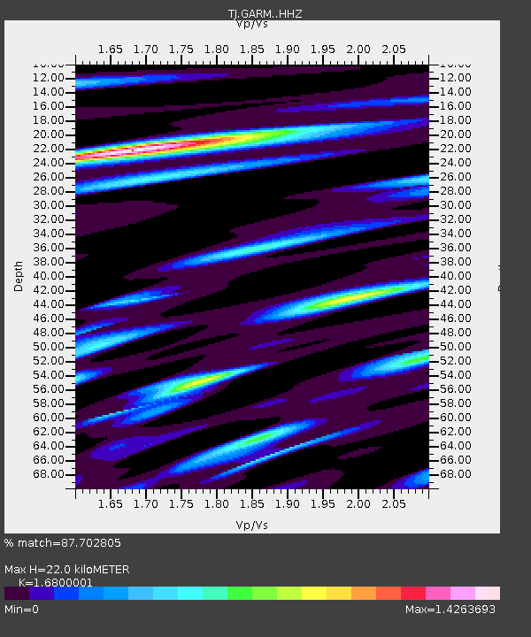
| Estimated Moho Depth: |
22.0 km |
| Estimated Crust Vp/Vs: |
1.68 |
| Assumed Crust Vp: |
6.306 km/s |
| Estimated Crust Vs: |
3.754 km/s |
| Estimated Crust Poisson's Ratio: |
0.23 |
|
| Radial Match: |
87.702805 % |
| Radial Bump: |
400 |
| Transverse Match: |
67.86529 % |
| Transverse Bump: |
400 |
| SOD ConfigId: |
20906531 |
| Insert Time: |
2020-04-11 15:49:22.641 +0000 |
| GWidth: |
2.5 |
| Max Bumps: |
400 |
| Tol: |
0.001 |
|
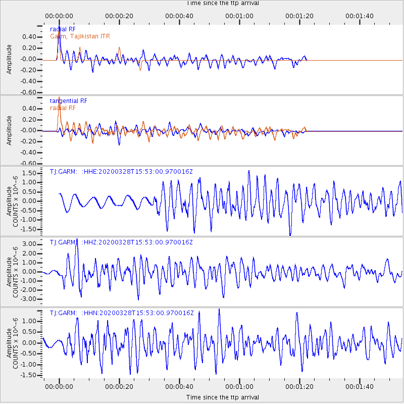
Signal To Noise
| Channel | StoN | STA | LTA |
| TJ:GARM: :HHZ:20200328T15:53:00.970016Z | 13.846033 | 9.546594E-7 | 6.894822E-8 |
| TJ:GARM: :HHN:20200328T15:53:00.970016Z | 1.2028685 | 2.8749554E-7 | 2.3900827E-7 |
| TJ:GARM: :HHE:20200328T15:53:00.970016Z | 1.6081429 | 4.0158045E-7 | 2.497169E-7 |
| Arrivals |
| Ps | 2.5 SECOND |
| PpPs | 8.9 SECOND |
| PsPs/PpSs | 11 SECOND |


