You are here: Home > Network List > IW - Intermountain West Stations List
> Station MOOW Moose Ponds, Wyoming, USA > Earthquake Result Viewer
MOOW Moose Ponds, Wyoming, USA - Earthquake Result Viewer
*The percent match for this event was below the threshold and hence no stack was calculated.
| Earthquake location: |
Vanuatu Islands |
| Earthquake latitude/longitude: |
-17.8/168.3 |
| Earthquake time(UTC): |
2020/03/28 (088) 17:48:16 GMT |
| Earthquake Depth: |
84 km |
| Earthquake Magnitude: |
5.8 mww |
| Earthquake Catalog/Contributor: |
NEIC PDE/us |
|
| Network: |
IW Intermountain West |
| Station: |
MOOW Moose Ponds, Wyoming, USA |
| Lat/Lon: |
43.75 N/110.74 W |
| Elevation: |
2128 m |
|
| Distance: |
95.8 deg |
| Az: |
46.0 deg |
| Baz: |
251.049 deg |
| Ray Param: |
$rayparam |
*The percent match for this event was below the threshold and hence was not used in the summary stack. |
|
| Radial Match: |
72.120125 % |
| Radial Bump: |
375 |
| Transverse Match: |
73.466934 % |
| Transverse Bump: |
400 |
| SOD ConfigId: |
20906531 |
| Insert Time: |
2020-04-11 17:54:46.877 +0000 |
| GWidth: |
2.5 |
| Max Bumps: |
400 |
| Tol: |
0.001 |
|
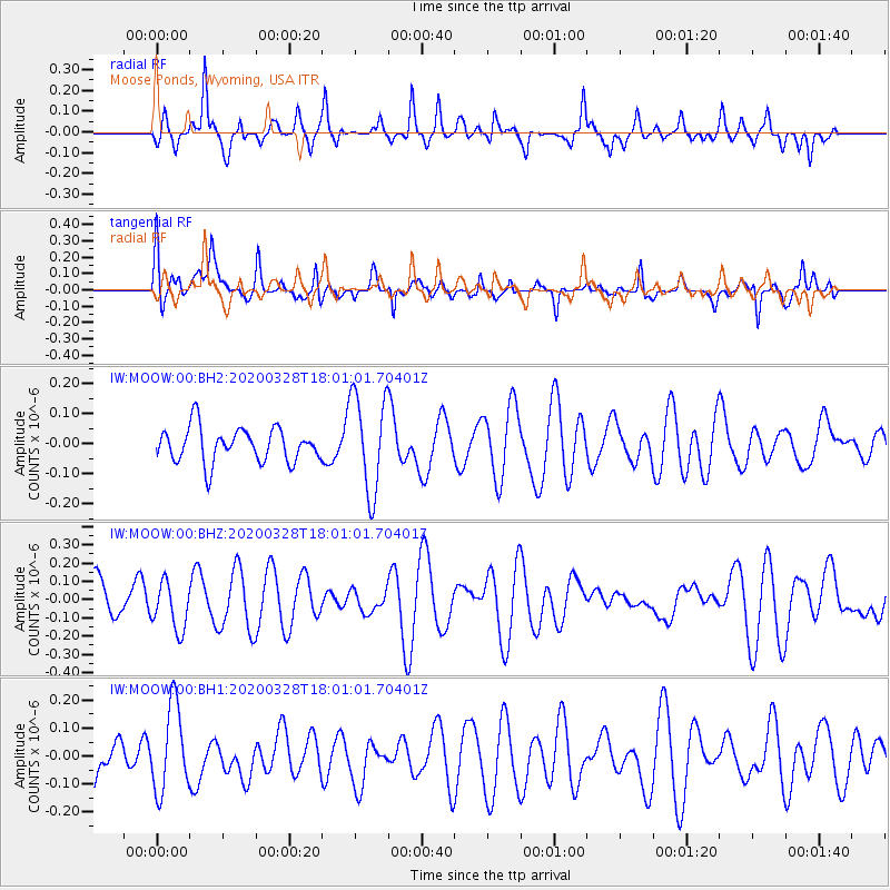
Signal To Noise
| Channel | StoN | STA | LTA |
| IW:MOOW:00:BHZ:20200328T18:01:01.70401Z | 1.1906549 | 1.2999818E-7 | 1.09182096E-7 |
| IW:MOOW:00:BH1:20200328T18:01:01.70401Z | 1.6435143 | 1.5292994E-7 | 9.3050566E-8 |
| IW:MOOW:00:BH2:20200328T18:01:01.70401Z | 2.858372 | 1.6279468E-7 | 5.6953635E-8 |
| Arrivals |
| Ps | |
| PpPs | |
| PsPs/PpSs | |


