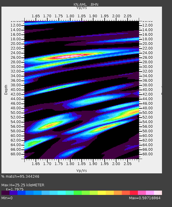
AML KN.AML - Earthquake Result Viewer

Earthquake location: Solomon Islands
Earthquake latitude/longitude: -9.6/159.5
Earthquake time(UTC): 2001/12/23 (357) 22:52:54 GMT
Earthquake Depth: 16 km
Earthquake Magnitude: 6.2 MB, 7.0 MS, 6.8 MW, 6.7 MW
Earthquake Catalog/Contributor: WHDF/NEIC
Network: KN Kyrgyz Seismic Telemetry Network
Station: AML KN.AML
Lat/Lon: 42.13 N/73.69 E
Elevation: 3400 m
Distance: 93.3 deg
Az: 312.002 deg
Baz: 99.878 deg
Ray Param: 0.04128476
Estimated Moho Depth: 25.25 km
Estimated Crust Vp/Vs: 1.80
Assumed Crust Vp: 6.316 km/s
Estimated Crust Vs: 3.514 km/s
Estimated Crust Poisson's Ratio: 0.28
Radial Match: 95.344246 %
Radial Bump: 400
Transverse Match: 89.583206 %
Transverse Bump: 400
SOD ConfigId: 20082
Insert Time: 2010-03-08 18:54:07.169 +0000
GWidth: 2.5
Max Bumps: 400
Tol: 0.001

Signal To Noise

ChannelStoNSTALTA
KN:AML: :BHN:20011223T23:05:36.60002Z1.02028247.01822E-86.878704E-8
KN:AML: :BHE:20011223T23:05:36.60002Z1.94450939.018152E-84.6377522E-8
KN:AML: :BHZ:20011223T23:05:36.60002Z2.47520922.3493124E-79.491369E-8
Arrivals
Ps3.3 SECOND
PpPs11 SECOND
PsPs/PpSs14 SECOND