You are here: Home > Network List > UU - University of Utah Regional Network Stations List
> Station CCUT Cedar City, UT, USA > Earthquake Result Viewer
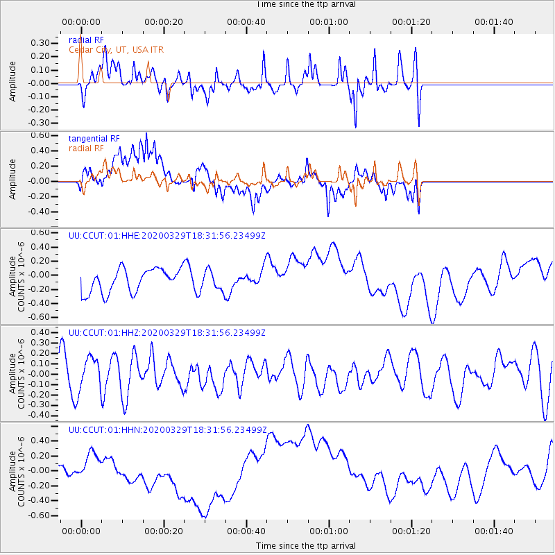
CCUT Cedar City, UT, USA - Earthquake Result Viewer
*The percent match for this event was below the threshold and hence no stack was calculated.
| Earthquake location: |
Southeast Of Loyalty Islands |
| Earthquake latitude/longitude: |
-21.4/169.5 |
| Earthquake time(UTC): |
2020/03/29 (089) 18:19:13 GMT |
| Earthquake Depth: |
10 km |
| Earthquake Magnitude: |
5.6 mww |
| Earthquake Catalog/Contributor: |
NEIC PDE/us |
|
| Network: |
UU University of Utah Regional Network |
| Station: |
CCUT Cedar City, UT, USA |
| Lat/Lon: |
37.55 N/113.36 W |
| Elevation: |
2127 m |
|
| Distance: |
93.2 deg |
| Az: |
50.911 deg |
| Baz: |
245.523 deg |
| Ray Param: |
$rayparam |
*The percent match for this event was below the threshold and hence was not used in the summary stack. |
|
| Radial Match: |
71.09395 % |
| Radial Bump: |
400 |
| Transverse Match: |
26.868893 % |
| Transverse Bump: |
400 |
| SOD ConfigId: |
20906531 |
| Insert Time: |
2020-04-12 18:29:51.731 +0000 |
| GWidth: |
2.5 |
| Max Bumps: |
400 |
| Tol: |
0.001 |
|
Signal To Noise
| Channel | StoN | STA | LTA |
| UU:CCUT:01:HHZ:20200329T18:31:56.23499Z | 1.0227491 | 1.5572628E-7 | 1.5226246E-7 |
| UU:CCUT:01:HHN:20200329T18:31:56.23499Z | 0.93402827 | 1.3544634E-7 | 1.450131E-7 |
| UU:CCUT:01:HHE:20200329T18:31:56.23499Z | 0.8209707 | 1.3690072E-7 | 1.667547E-7 |
| Arrivals |
| Ps | |
| PpPs | |
| PsPs/PpSs | |


