You are here: Home > Network List > UW - Pacific Northwest Regional Seismic Network Stations List
> Station WOLL Wollman Farm, Schrag, WA, USA > Earthquake Result Viewer
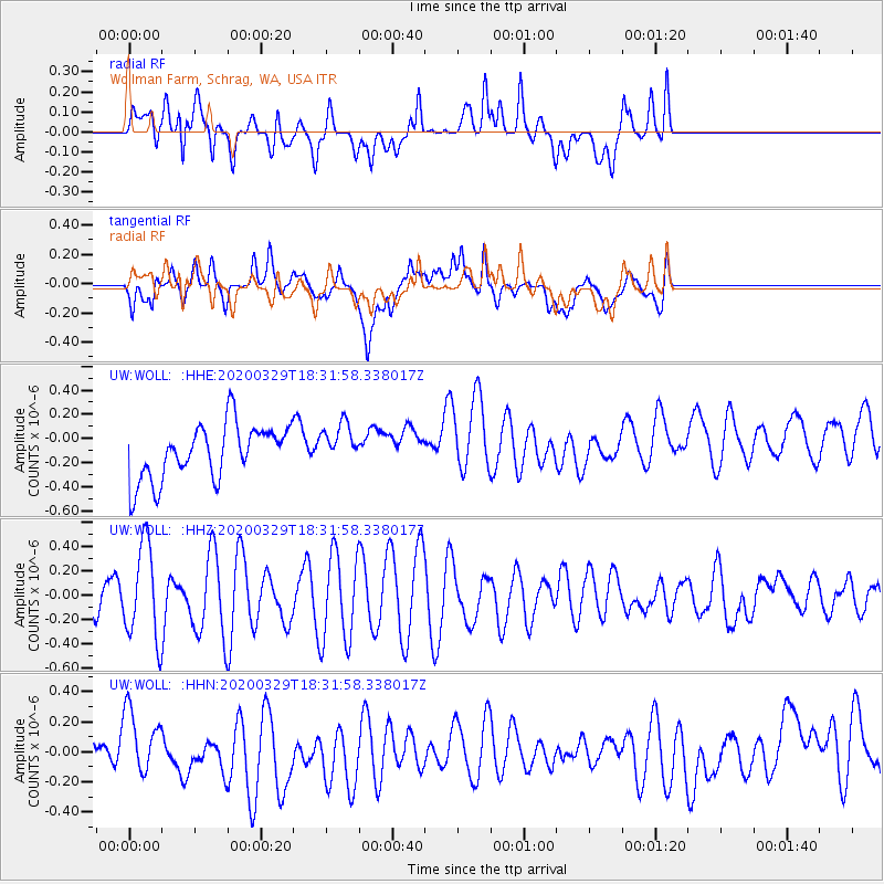
WOLL Wollman Farm, Schrag, WA, USA - Earthquake Result Viewer
*The percent match for this event was below the threshold and hence no stack was calculated.
| Earthquake location: |
Southeast Of Loyalty Islands |
| Earthquake latitude/longitude: |
-21.4/169.5 |
| Earthquake time(UTC): |
2020/03/29 (089) 18:19:13 GMT |
| Earthquake Depth: |
10 km |
| Earthquake Magnitude: |
5.6 mww |
| Earthquake Catalog/Contributor: |
NEIC PDE/us |
|
| Network: |
UW Pacific Northwest Regional Seismic Network |
| Station: |
WOLL Wollman Farm, Schrag, WA, USA |
| Lat/Lon: |
47.06 N/118.92 W |
| Elevation: |
385 m |
|
| Distance: |
93.6 deg |
| Az: |
40.552 deg |
| Baz: |
242.401 deg |
| Ray Param: |
$rayparam |
*The percent match for this event was below the threshold and hence was not used in the summary stack. |
|
| Radial Match: |
57.86666 % |
| Radial Bump: |
400 |
| Transverse Match: |
53.5893 % |
| Transverse Bump: |
400 |
| SOD ConfigId: |
20906531 |
| Insert Time: |
2020-04-12 18:30:41.258 +0000 |
| GWidth: |
2.5 |
| Max Bumps: |
400 |
| Tol: |
0.001 |
|
Signal To Noise
| Channel | StoN | STA | LTA |
| UW:WOLL: :HHZ:20200329T18:31:58.338017Z | 2.35935 | 3.82473E-7 | 1.6210949E-7 |
| UW:WOLL: :HHN:20200329T18:31:58.338017Z | 1.0459602 | 1.8346134E-7 | 1.7539993E-7 |
| UW:WOLL: :HHE:20200329T18:31:58.338017Z | 0.77445954 | 1.7621889E-7 | 2.2753788E-7 |
| Arrivals |
| Ps | |
| PpPs | |
| PsPs/PpSs | |


