You are here: Home > Network List > IU - Global Seismograph Network (GSN - IRIS/USGS) Stations List
> Station WVT Waverly, Tennessee, USA > Earthquake Result Viewer
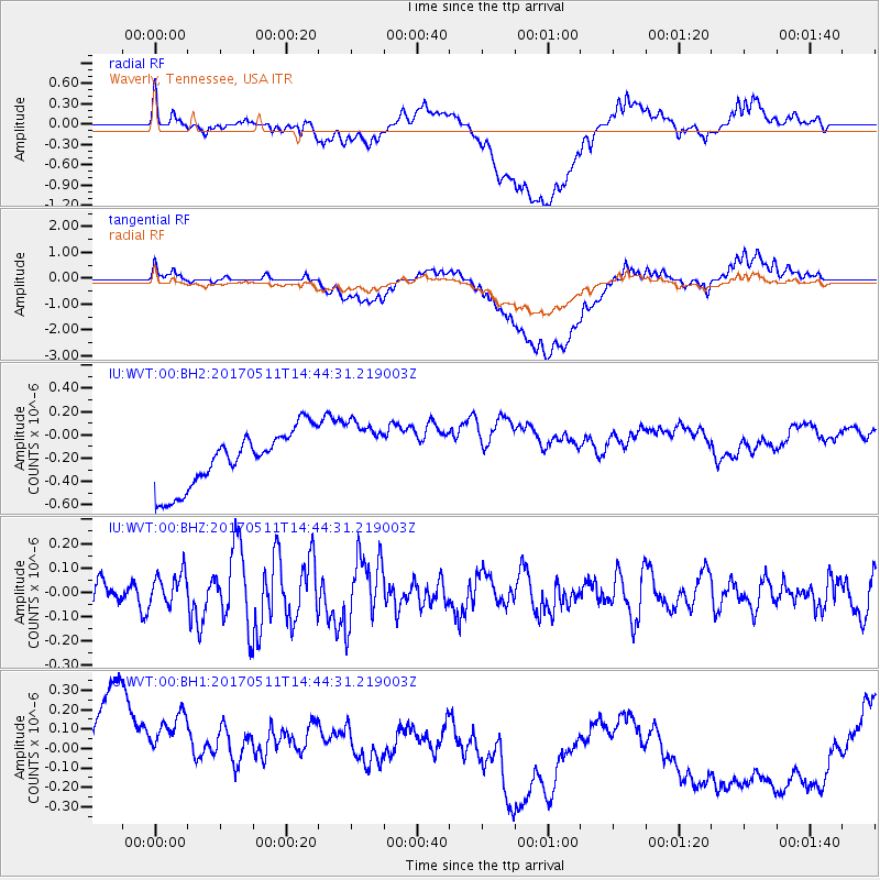
WVT Waverly, Tennessee, USA - Earthquake Result Viewer
*The percent match for this event was below the threshold and hence no stack was calculated.
| Earthquake location: |
Kodiak Island Region, Alaska |
| Earthquake latitude/longitude: |
56.8/-152.5 |
| Earthquake time(UTC): |
2017/05/11 (131) 14:36:30 GMT |
| Earthquake Depth: |
14 km |
| Earthquake Magnitude: |
5.5 Ml |
| Earthquake Catalog/Contributor: |
NEIC PDE/ak |
|
| Network: |
IU Global Seismograph Network (GSN - IRIS/USGS) |
| Station: |
WVT Waverly, Tennessee, USA |
| Lat/Lon: |
36.13 N/87.83 W |
| Elevation: |
170 m |
|
| Distance: |
47.1 deg |
| Az: |
87.36 deg |
| Baz: |
317.279 deg |
| Ray Param: |
$rayparam |
*The percent match for this event was below the threshold and hence was not used in the summary stack. |
|
| Radial Match: |
39.802406 % |
| Radial Bump: |
400 |
| Transverse Match: |
35.075325 % |
| Transverse Bump: |
400 |
| SOD ConfigId: |
2028011 |
| Insert Time: |
2017-05-25 14:39:17.360 +0000 |
| GWidth: |
2.5 |
| Max Bumps: |
400 |
| Tol: |
0.001 |
|
Signal To Noise
| Channel | StoN | STA | LTA |
| IU:WVT:00:BHZ:20170511T14:44:31.219003Z | 1.0549906 | 6.513703E-8 | 6.1741815E-8 |
| IU:WVT:00:BH1:20170511T14:44:31.219003Z | 0.7640554 | 4.4054798E-7 | 5.765917E-7 |
| IU:WVT:00:BH2:20170511T14:44:31.219003Z | 1.1594088 | 2.807305E-7 | 2.4213244E-7 |
| Arrivals |
| Ps | |
| PpPs | |
| PsPs/PpSs | |


