You are here: Home > Network List > CI - Caltech Regional Seismic Network Stations List
> Station MPP McPhearson Peak > Earthquake Result Viewer
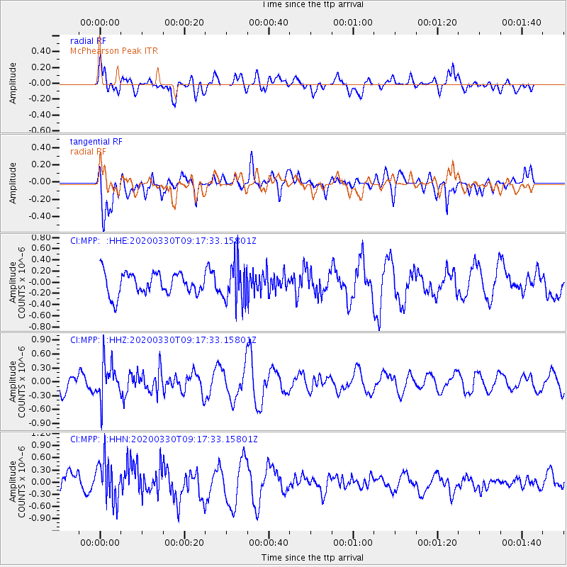
MPP McPhearson Peak - Earthquake Result Viewer
*The percent match for this event was below the threshold and hence no stack was calculated.
| Earthquake location: |
Colombia-Ecuador Border Region |
| Earthquake latitude/longitude: |
0.3/-77.7 |
| Earthquake time(UTC): |
2020/03/30 (090) 09:09:05 GMT |
| Earthquake Depth: |
128 km |
| Earthquake Magnitude: |
5.2 Mww |
| Earthquake Catalog/Contributor: |
NEIC PDE/us |
|
| Network: |
CI Caltech Regional Seismic Network |
| Station: |
MPP McPhearson Peak |
| Lat/Lon: |
34.89 N/119.81 W |
| Elevation: |
1739 m |
|
| Distance: |
52.2 deg |
| Az: |
315.761 deg |
| Baz: |
121.935 deg |
| Ray Param: |
$rayparam |
*The percent match for this event was below the threshold and hence was not used in the summary stack. |
|
| Radial Match: |
48.368027 % |
| Radial Bump: |
400 |
| Transverse Match: |
63.739735 % |
| Transverse Bump: |
400 |
| SOD ConfigId: |
20906531 |
| Insert Time: |
2020-04-13 09:14:55.822 +0000 |
| GWidth: |
2.5 |
| Max Bumps: |
400 |
| Tol: |
0.001 |
|
Signal To Noise
| Channel | StoN | STA | LTA |
| CI:MPP: :HHZ:20200330T09:17:33.15801Z | 2.787577 | 3.8511314E-7 | 1.3815337E-7 |
| CI:MPP: :HHN:20200330T09:17:33.15801Z | 1.5412499 | 5.0484795E-7 | 3.2755747E-7 |
| CI:MPP: :HHE:20200330T09:17:33.15801Z | 1.8482535 | 3.565229E-7 | 1.9289719E-7 |
| Arrivals |
| Ps | |
| PpPs | |
| PsPs/PpSs | |


