You are here: Home > Network List > IW - Intermountain West Stations List
> Station MOOW Moose Ponds, Wyoming, USA > Earthquake Result Viewer
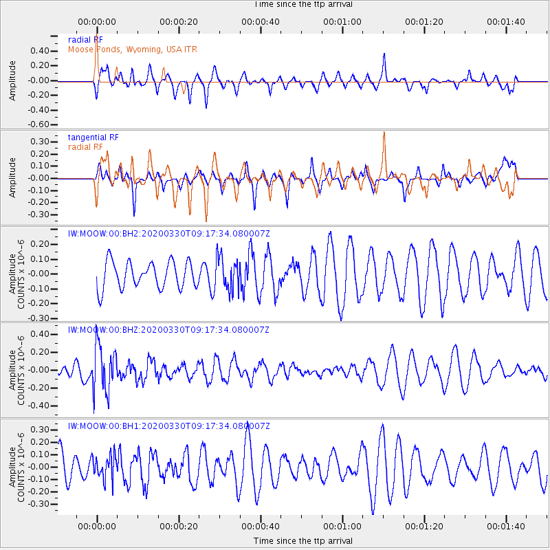
MOOW Moose Ponds, Wyoming, USA - Earthquake Result Viewer
*The percent match for this event was below the threshold and hence no stack was calculated.
| Earthquake location: |
Colombia-Ecuador Border Region |
| Earthquake latitude/longitude: |
0.3/-77.7 |
| Earthquake time(UTC): |
2020/03/30 (090) 09:09:05 GMT |
| Earthquake Depth: |
128 km |
| Earthquake Magnitude: |
5.2 Mww |
| Earthquake Catalog/Contributor: |
NEIC PDE/us |
|
| Network: |
IW Intermountain West |
| Station: |
MOOW Moose Ponds, Wyoming, USA |
| Lat/Lon: |
43.75 N/110.74 W |
| Elevation: |
2128 m |
|
| Distance: |
52.4 deg |
| Az: |
330.043 deg |
| Baz: |
136.447 deg |
| Ray Param: |
$rayparam |
*The percent match for this event was below the threshold and hence was not used in the summary stack. |
|
| Radial Match: |
58.458237 % |
| Radial Bump: |
400 |
| Transverse Match: |
34.0511 % |
| Transverse Bump: |
345 |
| SOD ConfigId: |
20906531 |
| Insert Time: |
2020-04-13 09:19:28.020 +0000 |
| GWidth: |
2.5 |
| Max Bumps: |
400 |
| Tol: |
0.001 |
|
Signal To Noise
| Channel | StoN | STA | LTA |
| IW:MOOW:00:BHZ:20200330T09:17:34.080007Z | 3.2001455 | 2.6668405E-7 | 8.333498E-8 |
| IW:MOOW:00:BH1:20200330T09:17:34.080007Z | 1.0714374 | 9.1859626E-8 | 8.5734946E-8 |
| IW:MOOW:00:BH2:20200330T09:17:34.080007Z | 1.2113577 | 1.0868686E-7 | 8.972318E-8 |
| Arrivals |
| Ps | |
| PpPs | |
| PsPs/PpSs | |


