You are here: Home > Network List > TS - TERRAscope (Southern California Seismic Network) Stations List
> Station RPV Rancho Palos Verde California, USA > Earthquake Result Viewer
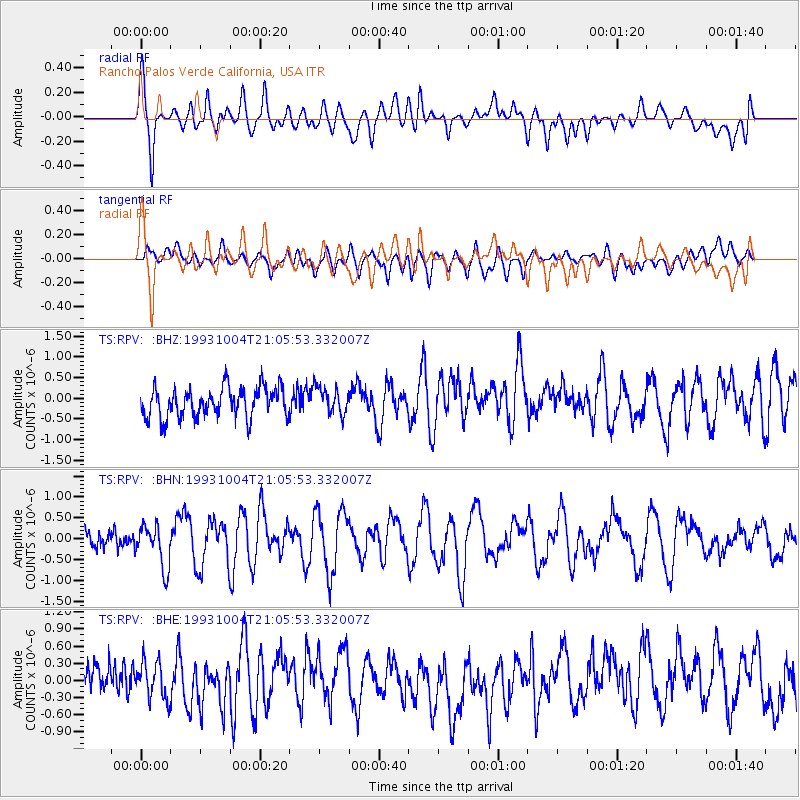
RPV Rancho Palos Verde California, USA - Earthquake Result Viewer
*The percent match for this event was below the threshold and hence no stack was calculated.
| Earthquake location: |
Tonga Islands |
| Earthquake latitude/longitude: |
-21.4/-174.4 |
| Earthquake time(UTC): |
1993/10/04 (277) 20:54:37 GMT |
| Earthquake Depth: |
33 km |
| Earthquake Magnitude: |
5.7 MB, 5.8 MS, 5.7 UNKNOWN, 5.8 MW |
| Earthquake Catalog/Contributor: |
WHDF/NEIC |
|
| Network: |
TS TERRAscope (Southern California Seismic Network) |
| Station: |
RPV Rancho Palos Verde California, USA |
| Lat/Lon: |
33.74 N/118.40 W |
| Elevation: |
115 m |
|
| Distance: |
76.5 deg |
| Az: |
45.264 deg |
| Baz: |
232.608 deg |
| Ray Param: |
$rayparam |
*The percent match for this event was below the threshold and hence was not used in the summary stack. |
|
| Radial Match: |
63.368626 % |
| Radial Bump: |
400 |
| Transverse Match: |
48.31388 % |
| Transverse Bump: |
400 |
| SOD ConfigId: |
4480 |
| Insert Time: |
2010-02-26 14:45:56.089 +0000 |
| GWidth: |
2.5 |
| Max Bumps: |
400 |
| Tol: |
0.001 |
|
Signal To Noise
| Channel | StoN | STA | LTA |
| TS:RPV: :BHN:19931004T21:05:53.332007Z | 2.8441725 | 5.0772303E-7 | 1.7851345E-7 |
| TS:RPV: :BHE:19931004T21:05:53.332007Z | 0.88189995 | 3.7509935E-7 | 4.2533094E-7 |
| TS:RPV: :BHZ:19931004T21:05:53.332007Z | 0.9274452 | 3.333675E-7 | 3.594471E-7 |
| Arrivals |
| Ps | |
| PpPs | |
| PsPs/PpSs | |


