You are here: Home > Network List > KN - Kyrgyz Seismic Telemetry Network Stations List
> Station AML KN.AML > Earthquake Result Viewer
AML KN.AML - Earthquake Result Viewer
| Earthquake location: |
Central Alaska |
| Earthquake latitude/longitude: |
63.5/-147.4 |
| Earthquake time(UTC): |
2002/11/03 (307) 22:12:41 GMT |
| Earthquake Depth: |
4.9 km |
| Earthquake Magnitude: |
7.0 MB, 8.5 MS, 7.9 MW |
| Earthquake Catalog/Contributor: |
WHDF/NEIC |
|
| Network: |
KN Kyrgyz Seismic Telemetry Network |
| Station: |
AML KN.AML |
| Lat/Lon: |
42.13 N/73.69 E |
| Elevation: |
3400 m |
|
| Distance: |
69.7 deg |
| Az: |
328.559 deg |
| Baz: |
18.324 deg |
| Ray Param: |
0.05545558 |
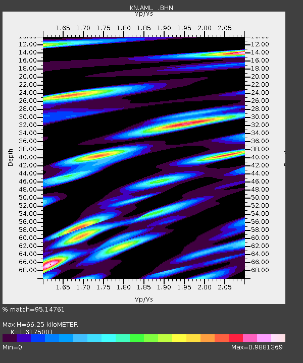
| Estimated Moho Depth: |
66.25 km |
| Estimated Crust Vp/Vs: |
1.62 |
| Assumed Crust Vp: |
6.316 km/s |
| Estimated Crust Vs: |
3.905 km/s |
| Estimated Crust Poisson's Ratio: |
0.19 |
|
| Radial Match: |
95.14761 % |
| Radial Bump: |
400 |
| Transverse Match: |
79.95124 % |
| Transverse Bump: |
400 |
| SOD ConfigId: |
4714 |
| Insert Time: |
2010-03-08 18:56:03.166 +0000 |
| GWidth: |
2.5 |
| Max Bumps: |
400 |
| Tol: |
0.001 |
|

Signal To Noise
| Channel | StoN | STA | LTA |
| KN:AML: :BHN:20021103T22:23:20.700012Z | 14.017021 | 1.7584603E-6 | 1.2545178E-7 |
| KN:AML: :BHE:20021103T22:23:20.700012Z | 7.927833 | 9.792312E-7 | 1.2351815E-7 |
| KN:AML: :BHZ:20021103T22:23:20.700012Z | 46.065006 | 4.5002093E-6 | 9.769258E-8 |
| Arrivals |
| Ps | 6.7 SECOND |
| PpPs | 26 SECOND |
| PsPs/PpSs | 33 SECOND |


