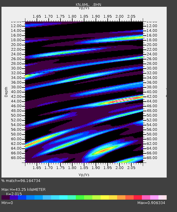
AML KN.AML - Earthquake Result Viewer

Earthquake location: Rat Islands, Aleutian Islands
Earthquake latitude/longitude: 51.3/178.0
Earthquake time(UTC): 2003/03/17 (076) 16:36:17 GMT
Earthquake Depth: 33 km
Earthquake Magnitude: 5.9 MB, 6.7 MS, 7.0 MW, 7.0 MW
Earthquake Catalog/Contributor: WHDF/NEIC
Network: KN Kyrgyz Seismic Telemetry Network
Station: AML KN.AML
Lat/Lon: 42.13 N/73.69 E
Elevation: 3400 m
Distance: 66.1 deg
Az: 307.973 deg
Baz: 41.738 deg
Ray Param: 0.05776843
Estimated Moho Depth: 43.25 km
Estimated Crust Vp/Vs: 2.02
Assumed Crust Vp: 6.316 km/s
Estimated Crust Vs: 3.134 km/s
Estimated Crust Poisson's Ratio: 0.34
Radial Match: 96.164734 %
Radial Bump: 400
Transverse Match: 92.58887 %
Transverse Bump: 400
SOD ConfigId: 4714
Insert Time: 2010-03-08 18:56:51.163 +0000
GWidth: 2.5
Max Bumps: 400
Tol: 0.001

Signal To Noise

ChannelStoNSTALTA
KN:AML: :BHN:20030317T16:46:30.450015Z12.0895188.9225296E-77.380385E-8
KN:AML: :BHE:20030317T16:46:30.450015Z15.169629.837833E-76.485221E-8
KN:AML: :BHZ:20030317T16:46:30.450015Z32.21993.181318E-69.873769E-8
Arrivals
Ps7.2 SECOND
PpPs20 SECOND
PsPs/PpSs27 SECOND