You are here: Home > Network List > TX - Texas Seismological Network Stations List
> Station WTFS Witchita Falls > Earthquake Result Viewer
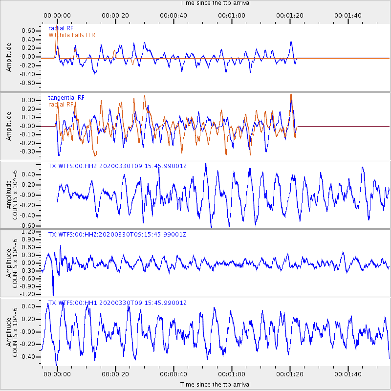
WTFS Witchita Falls - Earthquake Result Viewer
*The percent match for this event was below the threshold and hence no stack was calculated.
| Earthquake location: |
Colombia-Ecuador Border Region |
| Earthquake latitude/longitude: |
0.3/-77.7 |
| Earthquake time(UTC): |
2020/03/30 (090) 09:09:05 GMT |
| Earthquake Depth: |
128 km |
| Earthquake Magnitude: |
5.2 Mww |
| Earthquake Catalog/Contributor: |
NEIC PDE/us |
|
| Network: |
TX Texas Seismological Network |
| Station: |
WTFS Witchita Falls |
| Lat/Lon: |
33.77 N/98.46 W |
| Elevation: |
277 m |
|
| Distance: |
38.6 deg |
| Az: |
331.715 deg |
| Baz: |
145.331 deg |
| Ray Param: |
$rayparam |
*The percent match for this event was below the threshold and hence was not used in the summary stack. |
|
| Radial Match: |
64.80653 % |
| Radial Bump: |
400 |
| Transverse Match: |
53.563583 % |
| Transverse Bump: |
345 |
| SOD ConfigId: |
20906531 |
| Insert Time: |
2020-04-13 09:28:45.951 +0000 |
| GWidth: |
2.5 |
| Max Bumps: |
400 |
| Tol: |
0.001 |
|
Signal To Noise
| Channel | StoN | STA | LTA |
| TX:WTFS:00:HHZ:20200330T09:15:45.99001Z | 2.444497 | 2.735264E-7 | 1.1189476E-7 |
| TX:WTFS:00:HH1:20200330T09:15:45.99001Z | 1.7747339 | 2.9851736E-7 | 1.6820401E-7 |
| TX:WTFS:00:HH2:20200330T09:15:45.99001Z | 1.3409779 | 2.1601961E-7 | 1.6109111E-7 |
| Arrivals |
| Ps | |
| PpPs | |
| PsPs/PpSs | |


