You are here: Home > Network List > US - United States National Seismic Network Stations List
> Station AMTX Amarillo, Texas, USA > Earthquake Result Viewer
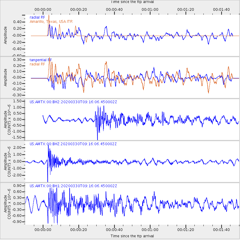
AMTX Amarillo, Texas, USA - Earthquake Result Viewer
*The percent match for this event was below the threshold and hence no stack was calculated.
| Earthquake location: |
Colombia-Ecuador Border Region |
| Earthquake latitude/longitude: |
0.3/-77.7 |
| Earthquake time(UTC): |
2020/03/30 (090) 09:09:05 GMT |
| Earthquake Depth: |
128 km |
| Earthquake Magnitude: |
5.2 Mww |
| Earthquake Catalog/Contributor: |
NEIC PDE/us |
|
| Network: |
US United States National Seismic Network |
| Station: |
AMTX Amarillo, Texas, USA |
| Lat/Lon: |
34.53 N/101.41 W |
| Elevation: |
1010 m |
|
| Distance: |
40.7 deg |
| Az: |
329.342 deg |
| Baz: |
141.858 deg |
| Ray Param: |
$rayparam |
*The percent match for this event was below the threshold and hence was not used in the summary stack. |
|
| Radial Match: |
51.31349 % |
| Radial Bump: |
400 |
| Transverse Match: |
48.39295 % |
| Transverse Bump: |
400 |
| SOD ConfigId: |
20906531 |
| Insert Time: |
2020-04-13 09:29:08.933 +0000 |
| GWidth: |
2.5 |
| Max Bumps: |
400 |
| Tol: |
0.001 |
|
Signal To Noise
| Channel | StoN | STA | LTA |
| US:AMTX:00:BHZ:20200330T09:16:06.450002Z | 6.6742635 | 9.1122917E-7 | 1.365288E-7 |
| US:AMTX:00:BH1:20200330T09:16:06.450002Z | 2.0939515 | 3.220606E-7 | 1.5380517E-7 |
| US:AMTX:00:BH2:20200330T09:16:06.450002Z | 3.5477486 | 4.515406E-7 | 1.2727526E-7 |
| Arrivals |
| Ps | |
| PpPs | |
| PsPs/PpSs | |


