You are here: Home > Network List > US - United States National Seismic Network Stations List
> Station ERPA Erie, Pennsylvania, USA > Earthquake Result Viewer
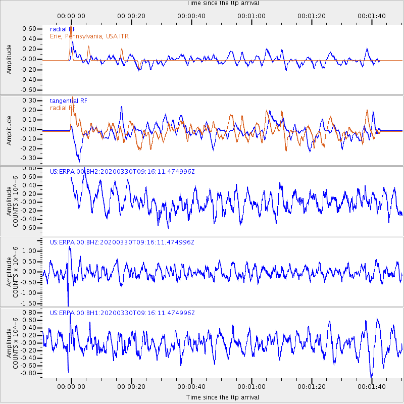
ERPA Erie, Pennsylvania, USA - Earthquake Result Viewer
*The percent match for this event was below the threshold and hence no stack was calculated.
| Earthquake location: |
Colombia-Ecuador Border Region |
| Earthquake latitude/longitude: |
0.3/-77.7 |
| Earthquake time(UTC): |
2020/03/30 (090) 09:09:05 GMT |
| Earthquake Depth: |
128 km |
| Earthquake Magnitude: |
5.2 Mww |
| Earthquake Catalog/Contributor: |
NEIC PDE/us |
|
| Network: |
US United States National Seismic Network |
| Station: |
ERPA Erie, Pennsylvania, USA |
| Lat/Lon: |
42.12 N/79.99 W |
| Elevation: |
306 m |
|
| Distance: |
41.7 deg |
| Az: |
357.418 deg |
| Baz: |
176.529 deg |
| Ray Param: |
$rayparam |
*The percent match for this event was below the threshold and hence was not used in the summary stack. |
|
| Radial Match: |
36.74622 % |
| Radial Bump: |
400 |
| Transverse Match: |
43.23206 % |
| Transverse Bump: |
400 |
| SOD ConfigId: |
20906531 |
| Insert Time: |
2020-04-13 09:29:22.242 +0000 |
| GWidth: |
2.5 |
| Max Bumps: |
400 |
| Tol: |
0.001 |
|
Signal To Noise
| Channel | StoN | STA | LTA |
| US:ERPA:00:BHZ:20200330T09:16:11.474996Z | 1.9481611 | 5.638501E-7 | 2.8942685E-7 |
| US:ERPA:00:BH1:20200330T09:16:11.474996Z | 1.1073502 | 3.1441655E-7 | 2.8393595E-7 |
| US:ERPA:00:BH2:20200330T09:16:11.474996Z | 1.6493444 | 4.0851583E-7 | 2.4768377E-7 |
| Arrivals |
| Ps | |
| PpPs | |
| PsPs/PpSs | |


