You are here: Home > Network List > US - United States National Seismic Network Stations List
> Station HLID Hailey, Idaho, USA > Earthquake Result Viewer
HLID Hailey, Idaho, USA - Earthquake Result Viewer
*The percent match for this event was below the threshold and hence no stack was calculated.
| Earthquake location: |
Colombia-Ecuador Border Region |
| Earthquake latitude/longitude: |
0.3/-77.7 |
| Earthquake time(UTC): |
2020/03/30 (090) 09:09:05 GMT |
| Earthquake Depth: |
128 km |
| Earthquake Magnitude: |
5.2 Mww |
| Earthquake Catalog/Contributor: |
NEIC PDE/us |
|
| Network: |
US United States National Seismic Network |
| Station: |
HLID Hailey, Idaho, USA |
| Lat/Lon: |
43.56 N/114.41 W |
| Elevation: |
1772 m |
|
| Distance: |
54.1 deg |
| Az: |
327.551 deg |
| Baz: |
132.43 deg |
| Ray Param: |
$rayparam |
*The percent match for this event was below the threshold and hence was not used in the summary stack. |
|
| Radial Match: |
56.428402 % |
| Radial Bump: |
400 |
| Transverse Match: |
50.550335 % |
| Transverse Bump: |
400 |
| SOD ConfigId: |
20906531 |
| Insert Time: |
2020-04-13 09:29:27.806 +0000 |
| GWidth: |
2.5 |
| Max Bumps: |
400 |
| Tol: |
0.001 |
|
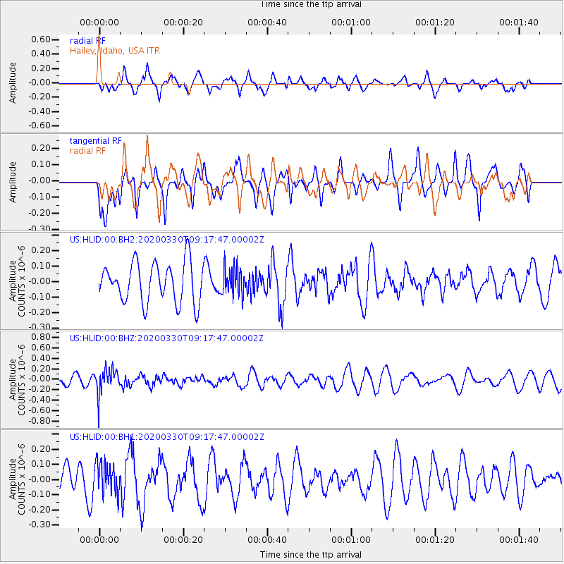
Signal To Noise
| Channel | StoN | STA | LTA |
| US:HLID:00:BHZ:20200330T09:17:47.00002Z | 2.5221899 | 2.448023E-7 | 9.705942E-8 |
| US:HLID:00:BH1:20200330T09:17:47.00002Z | 1.1420019 | 1.02422995E-7 | 8.968724E-8 |
| US:HLID:00:BH2:20200330T09:17:47.00002Z | 0.65668476 | 8.423655E-8 | 1.2827547E-7 |
| Arrivals |
| Ps | |
| PpPs | |
| PsPs/PpSs | |


